File:Map of California highlighting Del Norte County.svg

Size of this PNG preview of this SVG file: 521 × 599 pixels. Other resolutions: 209 × 240 pixels | 417 × 480 pixels | 667 × 768 pixels | 890 × 1,024 pixels | 1,780 × 2,048 pixels | 916 × 1,054 pixels.
Original file (SVG file, nominally 916 × 1,054 pixels, file size: 151 KB)
Captions
Captions
Add a one-line explanation of what this file represents
Summary
edit
| Description |
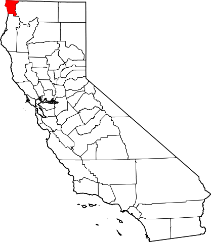
English: This is a locator map showing Del Norte County in California. For more information, see Commons:United States county locator maps. |
| Date | |
| Source |
Own work: English: The maps use data from nationalatlas.gov, specifically countyp020.tar.gz on the Raw Data Download page. The maps also use state outline data from statesp020.tar.gz. The Florida maps use hydrogm020.tar.gz to display Lake Okeechobee. |
| Author | David Benbennick |
Licensing
edit
| I, the copyright holder of this work, release this work into the public domain. This applies worldwide. In some countries this may not be legally possible; if so: I grant anyone the right to use this work for any purpose, without any conditions, unless such conditions are required by law. |
File history
Click on a date/time to view the file as it appeared at that time.
| Date/Time | Thumbnail | Dimensions | User | Comment | |
|---|---|---|---|---|---|
| current | 23:00, 25 June 2024 | | 916 × 1,054 (151 KB) | Nux (talk | contribs) | uniform colors with good contrast |
| 22:51, 25 June 2024 |  | 916 × 1,054 (151 KB) | Nux (talk | contribs) | uniform colors with good contrast | |
| 10:25, 12 February 2006 |  | 9,164 × 10,536 (229 KB) | David Benbennick (talk | contribs) | {{subst:User:Dbenbenn/clm|county=Del Norte County|state=California}} |
You cannot overwrite this file.
File usage on Commons
The following 8 pages use this file:
- Category:Births in Del Norte County, California
- Category:Del Norte County, California
- Category:Geography of Del Norte County, California
- Category:History of Del Norte County, California
- Category:Maps of Del Norte County, California
- Category:People of Del Norte County, California
- Category:Roads in Del Norte County, California
- Category:Transport in Del Norte County, California
File usage on other wikis
The following other wikis use this file:
- Usage on ar.wikipedia.org
- Usage on az.wikipedia.org
- Usage on ban.wikipedia.org
- Usage on be.wikipedia.org
- Usage on bpy.wikipedia.org
- Usage on ca.wikipedia.org
- Usage on ceb.wikipedia.org
- Usage on ce.wikipedia.org
- Usage on ckb.wikipedia.org
- Usage on cs.wikipedia.org
- Usage on cy.wikipedia.org
- Usage on da.wikipedia.org
- Usage on de.wikipedia.org
- Usage on en.wikipedia.org
- List of counties in California
- Del Norte County, California
- Bertsch–Oceanview, California
- Crescent City, California
- Crescent City North, California
- Klamath, California
- Template:Del Norte County, California
- Fort Ter-Waw
- Resighini Rancheria
- Yurok Indian Reservation
- Gasquet, California
- Smith River, California
- Category:Wikipedia requested photographs in Del Norte County, California
- National Register of Historic Places listings in Del Norte County, California
- Fort Dick, California
- Adams Station, California
- Darlingtonia, California
- Hiouchi, California
- Khoonkhwuttunne, California
- Khwunrghunme, California
- Klamath Glen, California
- Pacific Shores, California
View more global usage of this file.