File:Map of Michigan highlighting Otsego County.svg

Size of this PNG preview of this SVG file: 512 × 600 pixels. Other resolutions: 205 × 240 pixels | 410 × 480 pixels | 655 × 768 pixels | 874 × 1,024 pixels | 1,748 × 2,048 pixels | 962 × 1,127 pixels.
Original file (SVG file, nominally 962 × 1,127 pixels, file size: 138 KB)
Captions
Captions
Add a one-line explanation of what this file represents
Summary
edit
| Description |
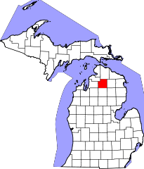
English: This is a locator map showing Otsego County in Michigan. For more information, see Commons:United States county locator maps. |
| Date | |
| Source |
Own work: English: The maps use data from nationalatlas.gov, specifically countyp020.tar.gz on the Raw Data Download page. The maps also use state outline data from statesp020.tar.gz. The Florida maps use hydrogm020.tar.gz to display Lake Okeechobee. |
| Author | David Benbennick |
Licensing
edit
| I, the copyright holder of this work, release this work into the public domain. This applies worldwide. In some countries this may not be legally possible; if so: I grant anyone the right to use this work for any purpose, without any conditions, unless such conditions are required by law. |
File history
Click on a date/time to view the file as it appeared at that time.
| Date/Time | Thumbnail | Dimensions | User | Comment | |
|---|---|---|---|---|---|
| current | 10:24, 25 June 2024 | | 962 × 1,127 (138 KB) | Nux (talk | contribs) | fix rendering (remove clipping) |
| 12:59, 12 February 2006 |  | 6,256 × 7,325 (205 KB) | David Benbennick (talk | contribs) | {{subst:User:Dbenbenn/clm|county=Otsego County|state=Michigan|type=county}} |
You cannot overwrite this file.
File usage on Commons
The following 3 pages use this file:
File usage on other wikis
The following other wikis use this file:
- Usage on ar.wikipedia.org
- Usage on bg.wikipedia.org
- Usage on bpy.wikipedia.org
- Usage on cdo.wikipedia.org
- Usage on ceb.wikipedia.org
- Usage on cy.wikipedia.org
- Usage on de.wikipedia.org
- Usage on en.wikipedia.org
- List of counties in Michigan
- Otsego County, Michigan
- Bagley Township, Michigan
- Charlton Township, Michigan
- Chester Township, Otsego County, Michigan
- Corwith Township, Michigan
- Dover Township, Otsego County, Michigan
- Hayes Township, Otsego County, Michigan
- Otsego Lake Township, Michigan
- Vanderbilt, Michigan
- Elmira Township, Michigan
- Gaylord, Michigan
- Livingston Township, Michigan
- Heart Lake (Michigan)
- User:Notorious4life/gallery
- Elmira, Michigan
- Johannesburg, Michigan
- Template:Otsego County, Michigan
- Waters, Michigan
- User:Nyttend/County templates/MI/2
- Category:Populated places in Otsego County, Michigan
- Vienna Corners, Michigan
- Template:OtsegoCountyMI-geo-stub
- Category:Wikipedia requested photographs in Otsego County, Michigan
- User:Notorious4life/sandbox
- Usage on eo.wikipedia.org
- Usage on es.wikipedia.org
- Usage on et.wikipedia.org
- Usage on eu.wikipedia.org
- Usage on fa.wikipedia.org
- Usage on fi.wikipedia.org
- Usage on frr.wikipedia.org
- Usage on fr.wikipedia.org
- Usage on hu.wikipedia.org
- Usage on hy.wikipedia.org
View more global usage of this file.