File:Map of Michigan highlighting St. Clair County.svg

Size of this PNG preview of this SVG file: 512 × 600 pixels. Other resolutions: 205 × 240 pixels | 410 × 480 pixels | 655 × 768 pixels | 874 × 1,024 pixels | 1,748 × 2,048 pixels | 962 × 1,127 pixels.
Original file (SVG file, nominally 962 × 1,127 pixels, file size: 138 KB)
Captions
Captions
Add a one-line explanation of what this file represents
Summary
edit
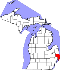
| Description | This is a locator map showing Saint Clair County in Michigan. |
| Source | David Benbennick made this map. For more information, see Commons:United States county locator maps. |
| Author | David Benbennick |
Licensing
edit
| I, the copyright holder of this work, release this work into the public domain. This applies worldwide. In some countries this may not be legally possible; if so: I grant anyone the right to use this work for any purpose, without any conditions, unless such conditions are required by law. |
File history
Click on a date/time to view the file as it appeared at that time.
| Date/Time | Thumbnail | Dimensions | User | Comment | |
|---|---|---|---|---|---|
| current | 11:55, 25 June 2024 | | 962 × 1,127 (138 KB) | Nux (talk | contribs) | fix rendering (remove clipping) |
| 13:00, 12 February 2006 |  | 6,256 × 7,325 (205 KB) | David Benbennick (talk | contribs) | {{subst:User:Dbenbenn/clm|county=Saint Clair County|state=Michigan|type=county}} |
You cannot overwrite this file.
File usage on Commons
The following 4 pages use this file:
File usage on other wikis
The following other wikis use this file:
- Usage on ar.wikipedia.org
- Usage on arz.wikipedia.org
- Usage on bg.wikipedia.org
- Usage on bpy.wikipedia.org
- Usage on cdo.wikipedia.org
- Usage on ceb.wikipedia.org
- Usage on cs.wikipedia.org
- Usage on cy.wikipedia.org
- Usage on de.wikipedia.org
- Usage on en.wikipedia.org
- List of counties in Michigan
- St. Clair County, Michigan
- Algonac, Michigan
- Berlin Township, St. Clair County, Michigan
- Brockway Township, Michigan
- Burtchville Township, Michigan
- Capac, Michigan
- Casco Township, St. Clair County, Michigan
- China Township, Michigan
- Clay Township, Michigan
- Clyde Township, St. Clair County, Michigan
- Columbus Township, St. Clair County, Michigan
- Cottrellville Township, Michigan
- East China Township, Michigan
- Emmett, Michigan
- Emmett Township, St. Clair County, Michigan
- Fort Gratiot Township, Michigan
- Grant Township, St. Clair County, Michigan
- Greenwood Township, St. Clair County, Michigan
- Kimball Township, Michigan
- Lynn Township, Michigan
- Marine City, Michigan
- Marysville, Michigan
- Mussey Township, Michigan
- Pearl Beach, St. Clair County, Michigan
- Port Huron, Michigan
- Port Huron Township, Michigan
- Riley Township, St. Clair County, Michigan
- St. Clair, Michigan
- St. Clair Township, Michigan
- Wales Township, Michigan
- Yale, Michigan
- Ira Township, Michigan
- Kenockee Township, Michigan
View more global usage of this file.