File:Map of Pettis County, Missouri, 1872 LOC 2012593079.jpg

Size of this preview: 478 × 600 pixels. Other resolutions: 191 × 240 pixels | 383 × 480 pixels | 612 × 768 pixels | 816 × 1,024 pixels | 1,633 × 2,048 pixels | 3,237 × 4,060 pixels.
Original file (3,237 × 4,060 pixels, file size: 2.58 MB, MIME type: image/jpeg)
Captions
Captions
Add a one-line explanation of what this file represents
Summary edit
| Description |
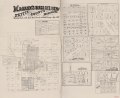
English: Shows names of some residents, boundary lines, and place names. Copy imperfect: Mounted on paper back, folded in half and mended along the fold line. Includes text. Available also through the Library of Congress Web site as a raster image. |
||
| Title | Magann's birds eye view map of Pettis County, Missouri : showing plats of the rail road town & sectional county map, 1872 | ||
| Shelf ID | G4163.P45G46 1872 .M32 | ||
| Date | |||
| Source | https://www.loc.gov/item/2012593079/ | ||
| Author | Magann, J. G. | ||
| Permission (Reusing this file) |
|
||
| Other versions |
|
||
| Location | United States · Pettis County · Missouri | ||
| Part of | American Memory · Catalog · County Landownership Maps · Geography And Map Division · Cultural Landscapes | ||
| Subject | Cadastral Maps · Pettis County · Maps · United States · Pettis County (Mo.) · Missouri · Aerial Views · Landowners |


Licensing edit
This work is in the public domain in the United States because it was published (or registered with the U.S. Copyright Office) before January 1, 1929.
Public domain works must be out of copyright in both the United States and in the source country of the work in order to be hosted on the Commons. If the work is not a U.S. work, the file must have an additional copyright tag indicating the copyright status in the source country.
Note: This tag should not be used for sound recordings. |
File history
Click on a date/time to view the file as it appeared at that time.
| Date/Time | Thumbnail | Dimensions | User | Comment | |
|---|---|---|---|---|---|
| current | 02:23, 3 May 2021 | | 3,237 × 4,060 (2.58 MB) | Buidhe (talk | contribs) | straighten, contrast |
| 02:11, 3 May 2021 |  | 3,459 × 4,233 (2.1 MB) | Buidhe (talk | contribs) | File:Magann's birds eye view map of Pettis County, Missouri - showing plats of the rail road town & sectional county map, 1872 LOC 2012593079.jpg cropped 75 % horizontally, 63 % vertically using CropTool with lossless mode. |
You cannot overwrite this file.
File usage on Commons
The following page uses this file:
File usage on other wikis
The following other wikis use this file:
- Usage on en.wikipedia.org