File:Map of the Azerbaijan Democratic Republic.png
Size of this preview: 800 × 565 pixels. Other resolutions: 320 × 226 pixels | 640 × 452 pixels | 1,024 × 724 pixels | 1,280 × 905 pixels | 2,463 × 1,741 pixels.
Original file (2,463 × 1,741 pixels, file size: 2.35 MB, MIME type: image/png)
Captions
Captions
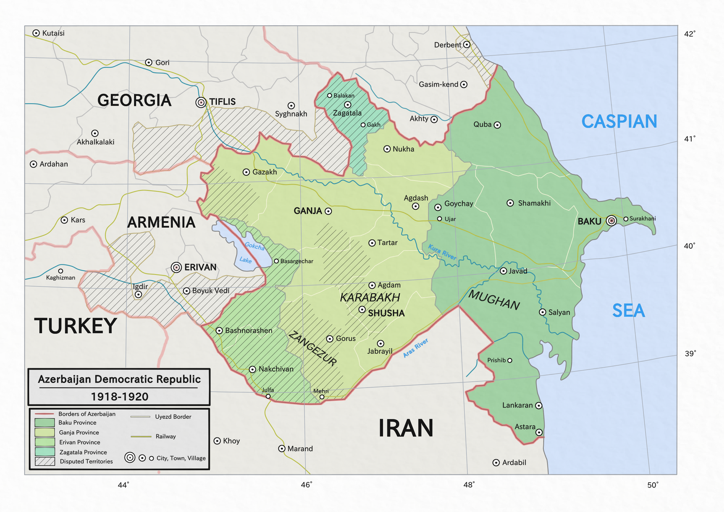
Map of the Azerbaijan Democratic Republic which existed from 1918 to 1920 with its territorial claims and disputed areas marked
Summary
edit
| Description |
Azərbaycanca: Azərbaycan Xalq Cümhutiyyətinin xəritəsi (1918-1920)
Türkçe: Azerbaycan Demokratik Cumhuriyetinin haritası (1918-1920)
Русский: Карта Азербайджанской Демократической Республики (1918-1920)
English: Map of Azerbaijan Democratic Republic (1918-1920) |
| Date | |
| Source |
Own work.
This PNG graphic was created with Medibang. |
| Author | Golden |
Licensing
edit
I, the copyright holder of this work, hereby publish it under the following license:
This file is licensed under the Creative Commons Attribution-Share Alike 4.0 International license.
- You are free:
- to share – to copy, distribute and transmit the work
- to remix – to adapt the work
- Under the following conditions:
- attribution – You must give appropriate credit, provide a link to the license, and indicate if changes were made. You may do so in any reasonable manner, but not in any way that suggests the licensor endorses you or your use.
- share alike – If you remix, transform, or build upon the material, you must distribute your contributions under the same or compatible license as the original.
This image has been assessed using the Quality image guidelines and is considered a Quality image.
|
File history
Click on a date/time to view the file as it appeared at that time.
| Date/Time | Thumbnail | Dimensions | User | Comment | |
|---|---|---|---|---|---|
| current | 16:22, 22 November 2021 | | 2,463 × 1,741 (2.35 MB) | Claude Zygiel (talk | contribs) | Other borders since Grosser Atlas zur Weltgeschichte, Westermann 1985, ISBN-3141009198, p. 149-151 |
| 16:42, 12 February 2021 |  | 2,463 × 1,741 (2.5 MB) | Golden (talk | contribs) | clean-up the map; Iravan -> Erivan; tweak some colours and text placements | |
| 18:03, 31 March 2020 |  | 2,463 × 1,741 (2.75 MB) | Golden (talk | contribs) | Uploaded own work with UploadWizard |
You cannot overwrite this file.
File usage on Commons
The following 6 pages use this file:
File usage on other wikis
The following other wikis use this file:
- Usage on af.wikipedia.org
- Usage on ar.wikipedia.org
- Usage on az.wikipedia.org
- Usage on br.wikipedia.org
- Usage on ckb.wikipedia.org
- Usage on cs.wikipedia.org
- Usage on de.wikipedia.org
- Usage on dsb.wikipedia.org
- Usage on en.wikipedia.org
- Usage on es.wikipedia.org
- Usage on fi.wikipedia.org
- Usage on fr.wikipedia.org
- Usage on gl.wikipedia.org
- Usage on hi.wikipedia.org
- Usage on hr.wikipedia.org
- Usage on hsb.wikipedia.org
- Usage on id.wikipedia.org
- Usage on it.wikipedia.org
- Usage on ka.wikipedia.org
- Usage on ko.wikipedia.org
- Usage on lt.wikipedia.org
- Usage on ms.wikipedia.org
- Usage on ro.wikipedia.org
- Usage on sr.wikibooks.org
- Usage on tr.wikipedia.org
- Usage on www.wikidata.org
- Usage on zh.wikipedia.org