File:Mapa da Província de Pernambuco (1889).tif

Size of this JPG preview of this TIF file: 800 × 332 pixels. Other resolutions: 320 × 133 pixels | 640 × 265 pixels | 1,024 × 424 pixels | 1,280 × 531 pixels | 2,560 × 1,061 pixels | 11,637 × 4,824 pixels.
Original file (11,637 × 4,824 pixels, file size: 98.39 MB, MIME type: image/tiff)
Captions
Captions
Add a one-line explanation of what this file represents
Summary
edit| Description |
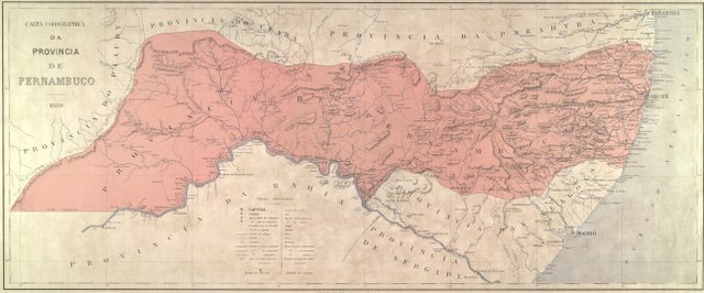
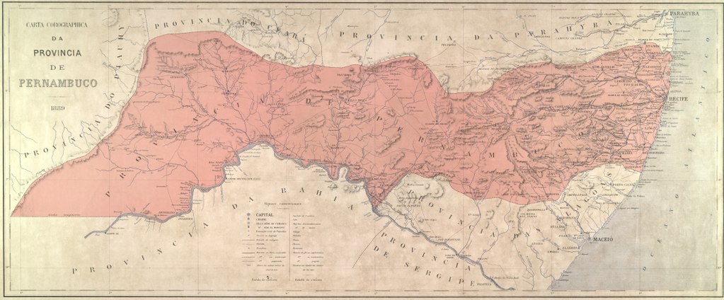
Português: Mapa da Província de Pernambuco. Fundo documental: Academia Brasileira de Letras |
||||||||||||||||||||||||||
| Date | |||||||||||||||||||||||||||
| Source |
|
||||||||||||||||||||||||||
| Creator |
Unknown author |
||||||||||||||||||||||||||
| Georeferencing | If inappropriate please set warp_status = skip to hide. | ||||||||||||||||||||||||||
| Other versions | |||||||||||||||||||||||||||
| Número de inventário | BR_RJANRIO_DS_0_MAP_0023 | ||||||||||||||||||||||||||

Licensing
editThis media is a faithful reproduction of public domain multimedia and it was the result of a GLAM partnership between the Arquivo Nacional and the Wikimedia Users Group in Brazil. The Arquivo Nacional (in English: The Brazilian National Archives) is an institution of the Brazilian Ministry of Justice and Public Security responsible for the management and preservation of documents pertaining to the federal public administration and located in the city of Rio de Janeiro.
Please attribute as: Public domain / Arquivo Nacional Collection Por favor, atribua como: Domínio público / Acervo Arquivo Nacional |
|
This work is in the public domain in its country of origin and other countries and areas where the copyright term is the author's life plus 100 years or fewer. This work is in the public domain in the United States because it was published (or registered with the U.S. Copyright Office) before January 1, 1929. | |
| This file has been identified as being free of known restrictions under copyright law, including all related and neighboring rights. | |
File history
Click on a date/time to view the file as it appeared at that time.
| Date/Time | Thumbnail | Dimensions | User | Comment | |
|---|---|---|---|---|---|
| current | 17:35, 18 April 2018 |  | 11,637 × 4,824 (98.39 MB) | Ederporto (talk | contribs) | User created page with UploadWizard |
You cannot overwrite this file.
File usage on Commons
The following page uses this file:
File usage on other wikis
The following other wikis use this file:
- Usage on pt.wikipedia.org