File:Mapa de corregimientos coloniales de Chile (1776).svg

Size of this PNG preview of this SVG file: 329 × 599 pixels. Other resolutions: 132 × 240 pixels | 263 × 480 pixels | 421 × 768 pixels | 562 × 1,024 pixels | 1,124 × 2,048 pixels | 1,474 × 2,685 pixels.
Original file (SVG file, nominally 1,474 × 2,685 pixels, file size: 4.53 MB)
Captions
Captions
Add a one-line explanation of what this file represents
Summary
edit.svg&action=edit§ion=1)
| Description |
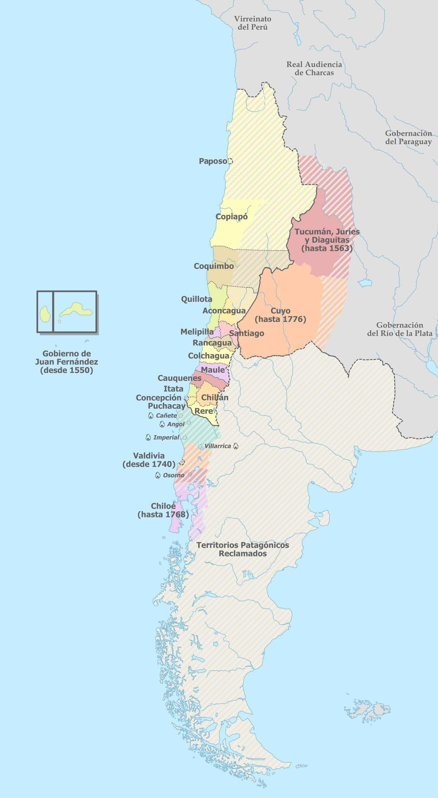
Español: Mapa de los corregimientos coloniales existentes en la Capitanía General de Chile hacia 1776. Se indican corregimientos transferidos a otras entidades territoriales coloniales (como Tucumán, Cuyo y Chiloé), territorios reclamados o nominalmente parte del territorio de la Capitanía.
Extensión de un corregimiento o gobiernos
Territorio sin delimitaciones claras o disputadas
Límite de territorio efectivo de la Capitanía hacia 1776.
Límite de territorio efectivo de la Capitanía hacia 1776 (extensión aproximada o sin definir).
Ciudades/corregimientos destruidas tras la rebelión mapuche de 1798, no reconstruidas.
Territorios patagónicos disputados, sin clara definición ni ocupación efectiva. |
| Date | |
| Source |
Own work This vector image includes elements that have been taken or adapted from this file: |
| Author | B1mbo |
,_administrative_divisions_-_en_-_colored_2018.svg)
Licensing
edit.svg&action=edit§ion=2)
I, the copyright holder of this work, hereby publish it under the following license:
This file is licensed under the Creative Commons Attribution-Share Alike 4.0 International license.
- You are free:
- to share – to copy, distribute and transmit the work
- to remix – to adapt the work
- Under the following conditions:
- attribution – You must give appropriate credit, provide a link to the license, and indicate if changes were made. You may do so in any reasonable manner, but not in any way that suggests the licensor endorses you or your use.
- share alike – If you remix, transform, or build upon the material, you must distribute your contributions under the same or compatible license as the original.
File history
Click on a date/time to view the file as it appeared at that time.
| Date/Time | Thumbnail | Dimensions | User | Comment | |
|---|---|---|---|---|---|
| current | 18:47, 29 December 2022 | | 1,474 × 2,685 (4.53 MB) | Janitoalevic (talk | contribs) | Precisión en las fronteras. |
| 18:46, 8 September 2022 |  | 1,474 × 2,685 (2.79 MB) | Janitoalevic (talk | contribs) | Ver discusión | |
| 06:29, 4 September 2022 |  | 1,474 × 2,685 (2.79 MB) | Floppa Historico (talk | contribs) | Reverted to version as of 01:42, 8 July 2022 (UTC) | |
| 22:45, 29 August 2022 |  | 1,474 × 2,685 (2.79 MB) | Janitoalevic (talk | contribs) | . | |
| 22:44, 29 August 2022 |  | 1,474 × 2,685 (2.79 MB) | Janitoalevic (talk | contribs) | Límite en la desembocadura del río Loa, pero no es la totalidad de este, ver mapa de Baleato. | |
| 01:42, 8 July 2022 |  | 1,474 × 2,685 (2.79 MB) | Janitoalevic (talk | contribs) | Arreglo ubicación del nombre "Audiencia de Charcas" | |
| 18:42, 7 July 2022 |  | 1,474 × 2,685 (2.79 MB) | Janitoalevic (talk | contribs) | Agrego Paposo | |
| 18:20, 7 July 2022 |  | 1,474 × 2,685 (2.79 MB) | Janitoalevic (talk | contribs) | límite en el río Loa entre la prov. de Santiago y Arequipa (Eyzaguirre, Jaime, 1967) | |
| 21:03, 19 September 2019 |  | 1,474 × 2,685 (2.78 MB) | B1mbo (talk | contribs) | text to path | |
| 21:01, 19 September 2019 |  | 1,474 × 2,685 (2.43 MB) | B1mbo (talk | contribs) | User created page with UploadWizard |
.jpg)
You cannot overwrite this file.
File usage on Commons
There are no pages that use this file.
File usage on other wikis
The following other wikis use this file:
- Usage on ca.wikipedia.org
- Usage on es.wikipedia.org
- Capitanía general de Chile
- Fronteras de Chile
- Paposo
- Corregimiento de La Concepción
- Corregimiento de Santiago
- Corregimiento de Coquimbo
- Corregimiento de Chillán
- Corregimiento de Osorno
- Corregimiento de Itata
- Corregimiento de Quillota
- Corregimiento de Aconcagua
- Corregimiento de Melipilla
- Corregimiento de Puchacay
- Corregimiento de Cauquenes
- Corregimiento de Rere
- Corregimientos de Chile
- Corregimiento de Rancagua
- Corregimiento de Maule
- Corregimiento de Angol
- Independentismo mendocino
.svg&oldid=720898980)