File:Maps of Moscow Governorate by Vasily Kiprianov 1711.jpg

Size of this preview: 800 × 600 pixels. Other resolutions: 320 × 240 pixels | 640 × 480 pixels | 1,024 × 767 pixels | 1,280 × 959 pixels | 2,560 × 1,919 pixels | 3,624 × 2,716 pixels.
Original file (3,624 × 2,716 pixels, file size: 4.34 MB, MIME type: image/jpeg)
Captions
Captions
Add a one-line explanation of what this file represents
Summary edit
| Description |
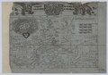
Русский: Губерния Московская разделенная в 9 провинций. Первая карта Московской губернии (1711 год). На карте Борисов и Боровск поменялись местами, а Можайск, Верея и Руза должны быть помещены к югу от реки Москвы, а Волоколамск, наоборот, к северу от реки Москвы. Цифра 4 изображена в зеркальном отражении. Источник:
English: Map of Moscow Governorate by Vasily Kiprianov, 1711 |
| Date | |
| Source | https://search.rsl.ru/ru/record/01008728173 |
| Author | Vasily Kiprianov |
| Other versions |
|
Licensing edit
|
This work is in the public domain in its country of origin and other countries and areas where the copyright term is the author's life plus 100 years or fewer. | |
| This file has been identified as being free of known restrictions under copyright law, including all related and neighboring rights. | |
File history
Click on a date/time to view the file as it appeared at that time.
| Date/Time | Thumbnail | Dimensions | User | Comment | |
|---|---|---|---|---|---|
| current | 17:52, 30 August 2018 | | 3,624 × 2,716 (4.34 MB) | Niklitov (talk | contribs) | User created page with UploadWizard |
You cannot overwrite this file.
File usage on Commons
The following 2 pages use this file:
File usage on other wikis
The following other wikis use this file:
- Usage on ru.wikipedia.org