File:Mount Hood, Oregon (1291134179).jpg

Original file (1,600 × 1,200 pixels, file size: 189 KB, MIME type: image/jpeg)
Captions
Captions
Summary
edit.jpg&action=edit§ion=1)
| Description |
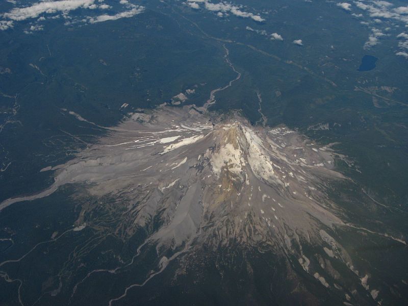
11,249 foot Mount Hood, one of the most spectacular mountains in the northwestern U.S. Mount Hood, called Wy'east by the Multnomah tribe, is a stratovolcano in the Cascade Volcanic Arc of northern Oregon. It was formed by a subduction zone and rests in the Pacific Northwest region of the United States. It is located about 50 miles (80 km) east-southeast of Portland, on the border between Clackamas and Hood River counties. Mount Hood's snow-covered peak rises 11,249 feet (3,429 m) and is home to twelve glaciers. (Older surveys said 11,239 feet (3,426 m), which is still often cited as its height). It is the highest mountain in Oregon and the fourth-highest in the Cascade Range. Mount Hood is considered the Oregon volcano most likely to erupt, though based on its history, an explosive eruption is unlikely. Still, the odds of an eruption in the next 30 years are estimated at between 3 and 7 percent, so the USGS characterizes it as "potentially active", but the mountain is informally considered dormant. Timberline Lodge is a National Historic Landmark located on the southern flank of Mount Hood just below Palmer Glacier. The mountain has six ski areas: Timberline, Mount Hood Meadows, Ski Bowl, Cooper Spur, Snow Bunny and Summit. They total over 4,600 acres (7.2 sq mi; 18.6 km2) of skiable terrain; Timberline offers the only year-round lift-served skiing in North America. Mount Hood is part of the Mount Hood National Forest, which has 1.067 million acres (1667 sq mi/4318 km²), four designated wilderness areas which total 189,200 acres (295.6 sq mi; 766 km2) acres and more than 1,200 miles (1,900 km) of hiking trails. The glacially eroded summit area consists of several andesitic or dacitic lava domes; Pleistocene collapses produced avalanches and lahars (rapidly moving mudflows) that traveled across the Columbia River to the north. The eroded volcano has had at least four major eruptive periods during the past 15,000 years. The last three at Mount Hood occurred within the past 1,800 years from vents high on the southwest flank and produced deposits that were distributed primarily to the south and west along the Sandy and Zigzag Rivers. The last eruptive period took place around 170 to 220 years ago, when dacitic lava domes, pyroclastic flows and mudflows were produced without major explosive eruptions. The prominent Crater Rock just below the summit is hypothesized to be the remains of one of these now-eroded domes. This period includes the last major eruption of 1781–82 with a slightly more recent episode ending shortly before the arrival of Lewis and Clark in 1805. The latest minor eruptive event occurred in August 1907. The glaciers on the mountain's upper slopes may be a source of potentially dangerous lahars when the mountain next erupts. There are vents near the summit that are known for emitting noxious gases such as carbon dioxide and sulfur dioxide. Since 1950, there have been several earthquake swarms each year at Mount Hood, most notably in July 1980 and June 2002. Seismic activity is monitored by the USGS Cascades Volcano Observatory located in Vancouver, Washington, which issues daily updates. Mount Hood's treeline varies from about 5,500 feet (1,700 m), mostly on the western faces, to about 7,000 feet (2,100 m), mostly on the eastern side. Mount Hood is host to twelve named glaciers or snow fields, the most visited of which is Palmer Glacier, partially within the Timberline Lodge ski area and on the most popular climbing route. The glaciers are almost exclusively above the 6,000-foot (1,800 m) level, which also is about the average tree line elevation on Mount Hood. More than 80% of the glacial surface area is above 7,000 feet (2,100 m). en.wikipedia.org/wiki/Mount_Hood en.wikipedia.org/wiki/Wikipedia:Text_of_Creative_Commons_... |
| Date | |
| Source | Mount Hood, Oregon |
| Author | Ken Lund from Reno, Nevada, USA |
| Camera location | | View this and other nearby images on: OpenStreetMap |
|---|
.jpg¶ms=045.376267_N_-121.693840_E_globe:Earth_type:camera_source:Flickr_&language=en)
Licensing
edit.jpg&action=edit§ion=2)
- You are free:
- to share – to copy, distribute and transmit the work
- to remix – to adapt the work
- Under the following conditions:
- attribution – You must give appropriate credit, provide a link to the license, and indicate if changes were made. You may do so in any reasonable manner, but not in any way that suggests the licensor endorses you or your use.
- share alike – If you remix, transform, or build upon the material, you must distribute your contributions under the same or compatible license as the original.
| This image was originally posted to Flickr by Ken Lund at https://flickr.com/photos/75683070@N00/1291134179. It was reviewed on 3 December 2015 by FlickreviewR and was confirmed to be licensed under the terms of the cc-by-sa-2.0. |
File history
Click on a date/time to view the file as it appeared at that time.
| Date/Time | Thumbnail | Dimensions | User | Comment | |
|---|---|---|---|---|---|
| current | 21:53, 3 December 2015 | | 1,600 × 1,200 (189 KB) | INeverCry (talk | contribs) | Transferred from Flickr via Flickr2Commons |
You cannot overwrite this file.
File usage on Commons
There are no pages that use this file.
.jpg&oldid=491125818)