File:Mount Rainier 5839s.JPG
Size of this preview: 450 × 600 pixels. Other resolutions: 180 × 240 pixels | 360 × 480 pixels | 576 × 768 pixels | 768 × 1,024 pixels | 1,536 × 2,048 pixels | 2,961 × 3,948 pixels.
Original file (2,961 × 3,948 pixels, file size: 2.45 MB, MIME type: image/jpeg)
Captions
Captions
Add a one-line explanation of what this file represents
| Description |
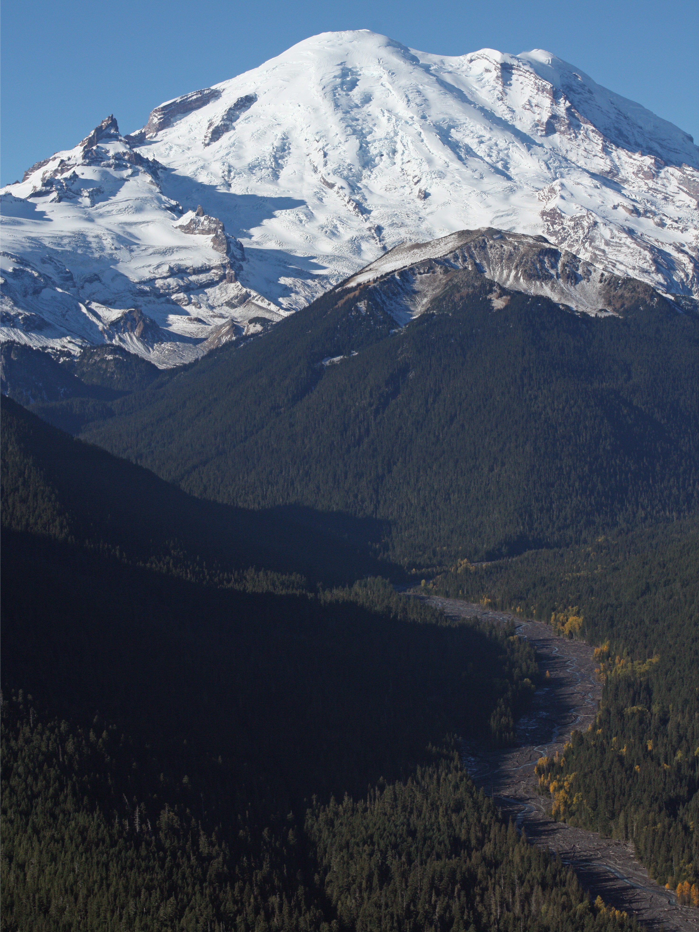
English: Mount Rainier with its main summit, Columbia Crest (14410 feet) at the center. Liberty Cap (14112 feet) is to the right behind Russell Cliff. Curtis Ridge descends to the right from Russell Cliff. Emmons Glacier covers most of the visible flank of the mountain. Winthrop Glacier flows right below Curtis Ridge and behind shallow Steamboat Prow (9680 feet) with the small Inter Glacier on its northeast face. Ingraham Glacier (left) is between Gibraltar Rock (12660 feet) high on the left skyline and Disappointment Cleaver. Left of Gibraltar Rock is sharp pointed Little Tahoma (11138 feet) with Frying Pan Glacier on its flank. It is the source of Frying Pan Creek in the valley left of forested and rounded Goat Island Mountain, in front of the Emmons Glacier. It flows into the White River which comes from the Emmons Glacier and flows around the right side of Goat Island Mountain in the watercourse visible below and right. |
| Date | 22 October 2008, 10:21:06 −07:00 |
| Source | Own work |
| Author | Walter Siegmund (talk) |
| Other versions |
|


| Camera location | | View this and other nearby images on: OpenStreetMap |
|---|
- Location source: Garmin GPSmap 60CSx
- Location Datum: WGS84
- Viewpoint location: Crystal Lakes Trail, Mount Rainier National Park
- Viewpoint elevation: 1602 meter (5254 ft)
- View direction: West-southwest
- Camera: Canon EOS DIGITAL REBEL XSi
- Exposure Time: 1/800
- F Number: f/11.0
- Focal Length: 70.0
- ISO Speed Rating: 400
{RetouchedPicture|Stitched two images; adjusted levels and color balance; please see other versions in the information template for the originals|editor=Wsiegmund|orig= |origoff=}} ©2009 Walter Siegmund
Licensing edit
I, the copyright holder of this work, hereby publish it under the following licenses:

|
Permission is granted to copy, distribute and/or modify this document under the terms of the GNU Free Documentation License, Version 1.2 or any later version published by the Free Software Foundation; with no Invariant Sections, no Front-Cover Texts, and no Back-Cover Texts. A copy of the license is included in the section entitled GNU Free Documentation License. |
This file is licensed under the Creative Commons Attribution-Share Alike 3.0 Unported, 2.5 Generic, 2.0 Generic and 1.0 Generic license.
- You are free:
- to share – to copy, distribute and transmit the work
- to remix – to adapt the work
- Under the following conditions:
- attribution – You must give appropriate credit, provide a link to the license, and indicate if changes were made. You may do so in any reasonable manner, but not in any way that suggests the licensor endorses you or your use.
- share alike – If you remix, transform, or build upon the material, you must distribute your contributions under the same or compatible license as the original.
You may select the license of your choice.
File history
Click on a date/time to view the file as it appeared at that time.
| Date/Time | Thumbnail | Dimensions | User | Comment | |
|---|---|---|---|---|---|
| current | 04:51, 13 March 2009 | | 2,961 × 3,948 (2.45 MB) | Wsiegmund (talk | contribs) | {{Information |Description = {{en|Mount Rainier with its main summit, Columbia Crest (14410 feet) at the center. Liberty Cap (14112 feet) is to the right behind Russell Cliff. Curtis Ridge descends to the right from Russell Cliff. Emmons Glacier cover |
You cannot overwrite this file.
File usage on Commons
The following 2 pages use this file: