File:Naturpark Oberpfaelzer Wald topomap.png

Size of this preview: 588 × 599 pixels. Other resolutions: 235 × 240 pixels | 471 × 480 pixels | 753 × 768 pixels | 1,004 × 1,024 pixels | 1,694 × 1,727 pixels.
Original file (1,694 × 1,727 pixels, file size: 1.91 MB, MIME type: image/png)
Captions
Captions
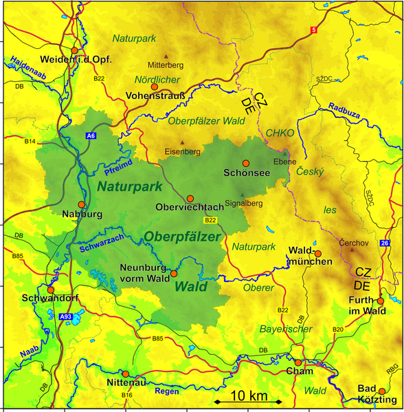
Position and topography of the Naturpark Oberpfälzer Wald
Summary
edit
| Description |
Deutsch: Karte zur Lage und Topografie des Naturparks Oberpfälzer Wald (grün hervorgehoben)
English: Map of the position and topography of the Naturpark Oberpfälzer Wald (emphasized in green) |
| Date | |
| Source | Own work |
| Author | Periphrastika |
Map data based on © OpenStreetMap and contributors. The ASTER L1B elevation data product was retrieved from the USGS EarthExplorer tool, courtesy of the NASA Land Processes Distributed Active Archive Center (LP DAAC), USGS/Earth Resources Observation and Science (EROS) Center, Sioux Falls, South Dakota, USA
Licensing
edit
I, the copyright holder of this work, hereby publish it under the following license:
This file is licensed under the Creative Commons Attribution-Share Alike 4.0 International license.
- You are free:
- to share – to copy, distribute and transmit the work
- to remix – to adapt the work
- Under the following conditions:
- attribution – You must give appropriate credit, provide a link to the license, and indicate if changes were made. You may do so in any reasonable manner, but not in any way that suggests the licensor endorses you or your use.
- share alike – If you remix, transform, or build upon the material, you must distribute your contributions under the same or compatible license as the original.
File history
Click on a date/time to view the file as it appeared at that time.
| Date/Time | Thumbnail | Dimensions | User | Comment | |
|---|---|---|---|---|---|
| current | 15:55, 5 November 2019 | | 1,694 × 1,727 (1.91 MB) | Periphrastika (talk | contribs) | User created page with UploadWizard |
You cannot overwrite this file.
File usage on Commons
There are no pages that use this file.
File usage on other wikis
The following other wikis use this file:
- Usage on de.wikipedia.org