File:NavassaIsland.jpeg
Size of this preview: 757 × 599 pixels. Other resolutions: 303 × 240 pixels | 606 × 480 pixels | 970 × 768 pixels | 1,280 × 1,013 pixels | 1,829 × 1,448 pixels.
Original file (1,829 × 1,448 pixels, file size: 751 KB, MIME type: image/jpeg)
Captions
Captions
Add a one-line explanation of what this file represents

Summary edit
| Description |
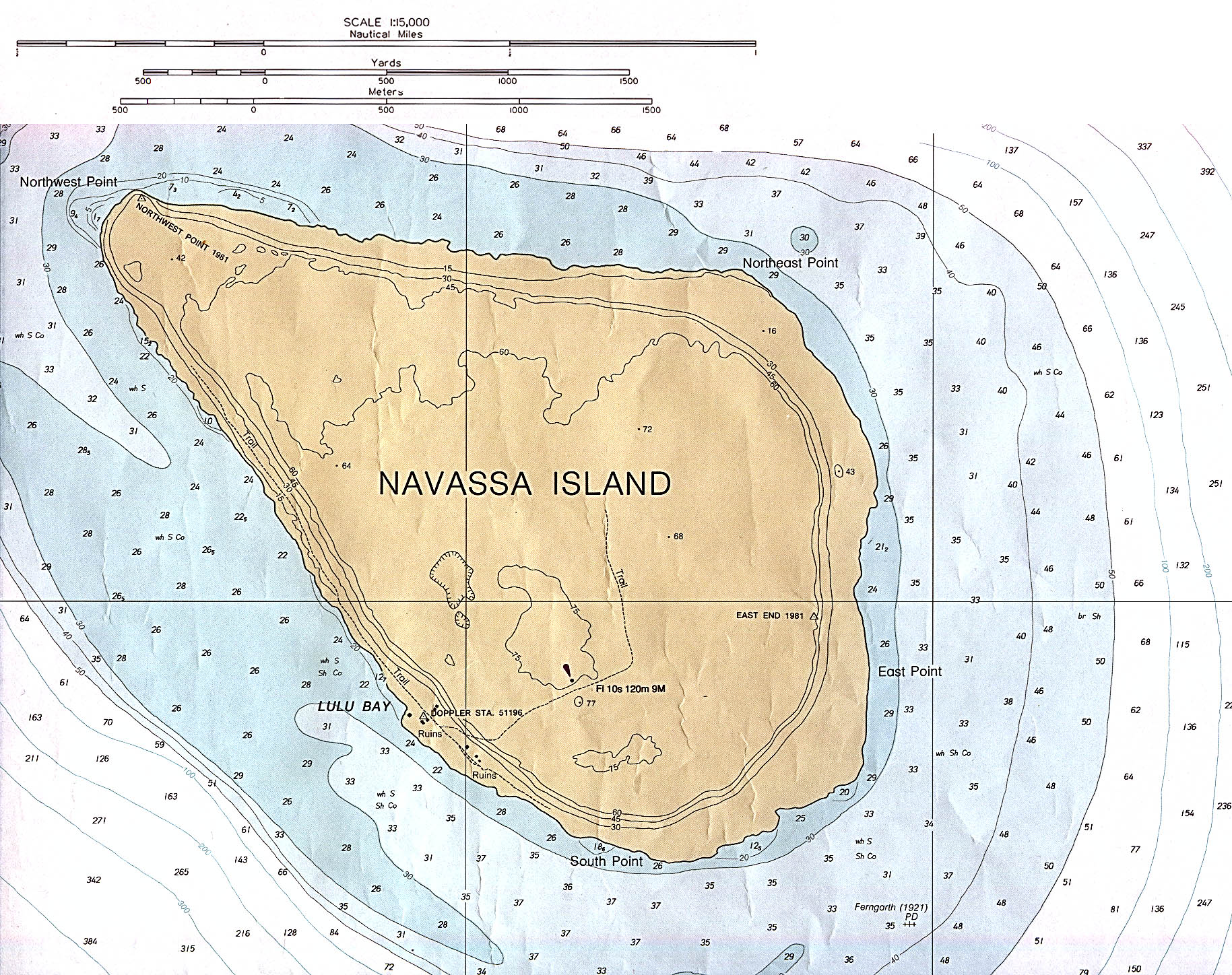
English: Navassa Island (Nautical Chart) original scale 1:15,000 Defense Mapping Agency 1982, revised 1991. |
| Date | 1982, revised 1991 |
| Source | description source: http://www.lib.utexas.edu/maps/navassa_island.html |
| Author | US Government - Defense Mapping Agency |
Licensing edit
This work is in the public domain in the United States because it is a work prepared by an officer or employee of the United States Government as part of that person’s official duties under the terms of Title 17, Chapter 1, Section 105 of the US Code.
Note: This only applies to original works of the Federal Government and not to the work of any individual U.S. state, territory, commonwealth, county, municipality, or any other subdivision. This template also does not apply to postage stamp designs published by the United States Postal Service since 1978. (See § 313.6(C)(1) of Compendium of U.S. Copyright Office Practices). It also does not apply to certain US coins; see The US Mint Terms of Use.
|
 | |
| This file has been identified as being free of known restrictions under copyright law, including all related and neighboring rights. | ||
File history
Click on a date/time to view the file as it appeared at that time.
| Date/Time | Thumbnail | Dimensions | User | Comment | |
|---|---|---|---|---|---|
| current | 23:49, 9 November 2012 | | 1,829 × 1,448 (751 KB) | Rd232 (talk | contribs) | Higher resolution version of file, from original PCL source |
| 00:37, 16 January 2006 |  | 466 × 429 (16 KB) | *drew~commonswiki (talk | contribs) | *Description: Navassa Island *Source: En Wikipedia {{PD}} Category:Caribbean |
You cannot overwrite this file.
File usage on Commons
The following page uses this file:
File usage on other wikis
The following other wikis use this file:
- Usage on cs.wikipedia.org
- Usage on de.wikipedia.org
- Usage on he.wikipedia.org
- Usage on jv.wikipedia.org
- Usage on ms.wikipedia.org