File:Nelson Mandela Bridge (4611829625).jpg

Original file (2,400 × 1,800 pixels, file size: 614 KB, MIME type: image/jpeg)
Captions
Captions
Summary
edit.jpg&action=edit§ion=1)
| Description |
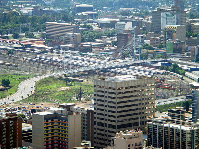
The Nelson Mandela Bridge is a bridge in Johannesburg, South Africa. It was completed in 2003 with an R38 million price tag. The proposal for the bridge was to link up two main business areas of Braamfontein and Newtown as well as to rejuvenate and to a certain level modernize the inner city, which is an initiative by a company, Blue IQ. The bridge was constructed over 42 railway lines without disturbing railway traffic and is 284 metres long. There are two pylons, North and South, and are 42 and 27 metres respectively. Engineers tried to keep the bridge as light as possible and used a structural steel with a concrete composite deck to keep weight down. Heavier banks along the bridge were reinforced by heavier back spans. The bridge consists of two lanes and has pedestrian walk-ways on either side. The bridge can be viewed from one of Johannesburg’s most popular roads, the M1 highway. Of recent times it has been known the many copper wiring has been stolen from the bridge which has causes tighter security measures, including full 24-hour video surveillance of the bridge. A bridge linking Braamfontein to the Johannesburg city centre was first mooted by Steve Thorne and Gordon Gibson, urban designers, in 1993 in their urban design study of the Inner City of Johannesburg. In their study they named the bridge the Nelson Mandela bridge in recognition of the role Nelson Mandela was having in uniting South African society, and the symbolism of linkage and unity provided by the bridge. [Wikipedia.org] |
| Date | |
| Source | Nelson Mandela Bridge |
| Author | Jorge Láscar from Australia |
| Camera location | | View this and other nearby images on: OpenStreetMap |
|---|
.jpg¶ms=-26.196700_N_0028.034200_E_globe:Earth_type:camera_source:Flickr_&language=en)
Licensing
edit.jpg&action=edit§ion=2)
- You are free:
- to share – to copy, distribute and transmit the work
- to remix – to adapt the work
- Under the following conditions:
- attribution – You must give appropriate credit, provide a link to the license, and indicate if changes were made. You may do so in any reasonable manner, but not in any way that suggests the licensor endorses you or your use.
| This image was originally posted to Flickr by Jorge Lascar at https://www.flickr.com/photos/8721758@N06/4611829625. It was reviewed on 2 April 2014 by FlickreviewR and was confirmed to be licensed under the terms of the cc-by-2.0. |
File history
Click on a date/time to view the file as it appeared at that time.
| Date/Time | Thumbnail | Dimensions | User | Comment | |
|---|---|---|---|---|---|
| current | 07:50, 2 April 2014 | | 2,400 × 1,800 (614 KB) | Russavia (talk | contribs) | Transferred from Flickr |
You cannot overwrite this file.
File usage on Commons
There are no pages that use this file.
File usage on other wikis
The following other wikis use this file:
- Usage on fr.wikipedia.org
.jpg&oldid=882711999)