File:Nong Ta Kla.jpg
![File:Nong Ta Kla.jpg](https://upload.wikimedia.org/wikipedia/commons/thumb/c/c8/Nong_Ta_Kla.jpg/800px-Nong_Ta_Kla.jpg?20200202182313)
Size of this preview: 800 × 450 pixels. Other resolutions: 320 × 180 pixels | 640 × 360 pixels | 1,024 × 576 pixels | 1,280 × 720 pixels | 2,560 × 1,440 pixels | 4,032 × 2,268 pixels.
Original file (4,032 × 2,268 pixels, file size: 3.86 MB, MIME type: image/jpeg)
File information
Structured data
Captions
Captions
Add a one-line explanation of what this file represents
Roi Et [TH]
Summary
edit Thailand
Changwat Roi Et / Roi Et
DescriptionNong Ta Kla.jpg |
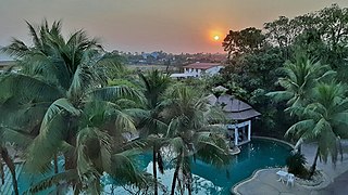
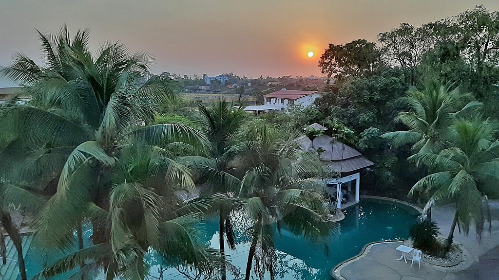
Deutsch: Ban Nong Ta Kla von Roi Et bei Sonnenaufgang (Hotel-Schwimmbad). |
Date | Taken on 12 January 2020, 06:53:41 |
Source | Own work |
Author | FkMohr |
Camera location | 16° 04′ 05.2″ N, 103° 39′ 16.48″ E ![]() ![]() | View this and other nearby images on: OpenStreetMap | ![]() |
---|
TH {XP200112-0653}
Licensing
editFriedrich-Karl Mohr, the copyright holder of this work, hereby publishes it under the following license:
![w:en:Creative Commons](https://upload.wikimedia.org/wikipedia/commons/thumb/7/79/CC_some_rights_reserved.svg/90px-CC_some_rights_reserved.svg.png)
![attribution](https://upload.wikimedia.org/wikipedia/commons/thumb/1/11/Cc-by_new_white.svg/24px-Cc-by_new_white.svg.png)
This file is licensed under the Creative Commons Attribution 3.0 Germany license.
Attribution: Friedrich-Karl Mohr
- You are free:
- to share – to copy, distribute and transmit the work
- to remix – to adapt the work
- Under the following conditions:
- attribution – You must give appropriate credit, provide a link to the license, and indicate if changes were made. You may do so in any reasonable manner, but not in any way that suggests the licensor endorses you or your use.
![](https://upload.wikimedia.org/wikipedia/commons/thumb/b/ba/Flag_of_Germany.svg/90px-Flag_of_Germany.svg.png)
File history
Click on a date/time to view the file as it appeared at that time.
Date/Time | Thumbnail | Dimensions | User | Comment | |
---|---|---|---|---|---|
current | 18:23, 2 February 2020 | ![]() | 4,032 × 2,268 (3.86 MB) | FkMohr (talk | contribs) | User created page with UploadWizard |
You cannot overwrite this file.
File usage on Commons
There are no pages that use this file.
Metadata
This file contains additional information such as Exif metadata which may have been added by the digital camera, scanner, or software program used to create or digitize it. If the file has been modified from its original state, some details such as the timestamp may not fully reflect those of the original file. The timestamp is only as accurate as the clock in the camera, and it may be completely wrong.
Image title |
|
---|---|
Camera manufacturer | samsung |
Camera model | SM-A505FN |
Author | 20200112_065341;Friedo |
Copyright holder |
|
Exposure time | 1/679 sec (0.0014727540500736) |
F-number | f/1.7 |
ISO speed rating | 40 |
Date and time of data generation | 06:53, 12 January 2020 |
Lens focal length | 3.93 mm |
Latitude | 16° 4′ 5.2″ N |
Longitude | 103° 39′ 16.48″ E |
Altitude | 160 meters above sea level |
Short title |
|
City shown | Muang Roi Et |
Width | 4,032 px |
Height | 2,268 px |
Orientation | Normal |
Horizontal resolution | 72 dpi |
Vertical resolution | 72 dpi |
Software used | A505FNXXU3ASL6 |
File change date and time | 19:11, 2 February 2020 |
Y and C positioning | Centered |
Exposure Program | Normal program |
Exif version | 2.2 |
Date and time of digitizing | 06:53, 12 January 2020 |
APEX shutter speed | 0.0014727540500736 |
APEX aperture | 1.53 |
APEX brightness | 18.97 |
Maximum land aperture | 1.53 APEX (f/1.7) |
Metering mode | Spot |
Flash | Flash did not fire |
Color space | sRGB |
Exposure mode | Auto exposure |
White balance | Auto white balance |
Digital zoom ratio | 1 |
Focal length in 35 mm film | 26 mm |
Scene capture type | Standard |
Unique image ID | 02D2FF4FEFFA4AE397D50D615A5DB7BA |
GPS time (atomic clock) | 23:53 |
Reference for direction of image | True direction |
Direction of image | 111.52 |
Geodetic survey data used | WGS-84 |
Latitude destination | 16° 3′ 51.65″ N |
Longitude of destination | 103° 39′ 52.25″ E |
GPS date | 11 January 2020 |
GPS tag version | 2.2.0.0 |
Image width | 4,032 px |
Image height | 2,268 px |
Code for country shown | THA |
Sublocation of city shown | Ban Nong Ta Kla |
Country shown | Thailand |
Province or state shown | Roi Et |
IIM version | 4 |