File:Nova totius terrarum orbis geographica ac hydrographica tabula (990027185480205171).tif

Size of this JPG preview of this TIF file: 800 × 583 pixels. Other resolutions: 320 × 233 pixels | 640 × 467 pixels | 1,024 × 747 pixels | 1,280 × 934 pixels | 2,560 × 1,867 pixels | 9,163 × 6,683 pixels.
Original file (9,163 × 6,683 pixels, file size: 175.23 MB, MIME type: image/tiff)
Captions
Captions
Add a one-line explanation of what this file represents
Summary edit
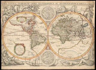
| Jodocus Hondius II: Nova Totius Terrarum Orbis Geographica ac Hydrographica Tabula
|
||||||||||||||||||||||||||||||||||||||||||||||||||||||||||||
|---|---|---|---|---|---|---|---|---|---|---|---|---|---|---|---|---|---|---|---|---|---|---|---|---|---|---|---|---|---|---|---|---|---|---|---|---|---|---|---|---|---|---|---|---|---|---|---|---|---|---|---|---|---|---|---|---|---|---|---|---|
| Artist |
|
.jpg) | ||||||||||||||||||||||||||||||||||||||||||||||||||||||||||
| Title |
Latin: Nova Totius Terrarum Orbis Geographica ac Hydrographica Tabula Nova Totius Terrarum Orbis Geographica ac Hydrographica Tabula |
|||||||||||||||||||||||||||||||||||||||||||||||||||||||||||
| Publisher | ||||||||||||||||||||||||||||||||||||||||||||||||||||||||||||
| Object type |
antique map / manuscript map / world map / double hemisphere world map / early world maps |
|||||||||||||||||||||||||||||||||||||||||||||||||||||||||||
| Genre |
map |
|||||||||||||||||||||||||||||||||||||||||||||||||||||||||||
| Description |
Latina: Nova totius terrarum orbis geographica ac hydrographica tabula [cartographic material] / Auct Iud. Hondio.
English: The map is based on Hondius' World map of 1617. The map was the first to show Le Maire's Straits and the islands in the Pacific discovered by Le Maire and his explorations in New Guines. Hondius' map was also one of the earliest to show Hudson's Bay and the full course of th St. Lawrence in a curious configuration. |
|||||||||||||||||||||||||||||||||||||||||||||||||||||||||||
| Language |
Latin |
|||||||||||||||||||||||||||||||||||||||||||||||||||||||||||
| Date |
circa |
|||||||||||||||||||||||||||||||||||||||||||||||||||||||||||
| Publication date |
circa |
|||||||||||||||||||||||||||||||||||||||||||||||||||||||||||
| Dimensions |
height: 39 cm (15.3 in) |
|||||||||||||||||||||||||||||||||||||||||||||||||||||||||||
| Collection |
|
|||||||||||||||||||||||||||||||||||||||||||||||||||||||||||
| Current location |
|
|||||||||||||||||||||||||||||||||||||||||||||||||||||||||||
| Place of publication |
Paris |
|||||||||||||||||||||||||||||||||||||||||||||||||||||||||||
| Notes | ||||||||||||||||||||||||||||||||||||||||||||||||||||||||||||
| NLI call number | W 14 | |||||||||||||||||||||||||||||||||||||||||||||||||||||||||||
| IE PID | IE13736752 | |||||||||||||||||||||||||||||||||||||||||||||||||||||||||||
| Rosetta filename | FL13746878 | |||||||||||||||||||||||||||||||||||||||||||||||||||||||||||
| NNL item ID (P3959) | 990027185480205171 | |||||||||||||||||||||||||||||||||||||||||||||||||||||||||||
| search Merhav catalog | world map, Jodocus Hondius II, Michael van Lochom, Latin, 1636, early world maps, antique map, manuscript map, double hemisphere world map | |||||||||||||||||||||||||||||||||||||||||||||||||||||||||||
| Authority file | ||||||||||||||||||||||||||||||||||||||||||||||||||||||||||||
| Source/Photographer |
|
|||||||||||||||||||||||||||||||||||||||||||||||||||||||||||
| Other versions | ||||||||||||||||||||||||||||||||||||||||||||||||||||||||||||
| Jpg / Tif version |
|
|||||||||||||||||||||||||||||||||||||||||||||||||||||||||||


Licensing edit
|
This work is in the public domain in its country of origin and other countries and areas where the copyright term is the author's life plus 100 years or fewer. This work is in the public domain in the United States because it was published (or registered with the U.S. Copyright Office) before January 1, 1929. | |
| This file has been identified as being free of known restrictions under copyright law, including all related and neighboring rights. | |
File history
Click on a date/time to view the file as it appeared at that time.
| Date/Time | Thumbnail | Dimensions | User | Comment | |
|---|---|---|---|---|---|
| current | 12:25, 23 July 2023 |  | 9,163 × 6,683 (175.23 MB) | Geagea (talk | contribs) | c:User:Rillke/bigChunkedUpload.js: == {{int:filedesc}} == {{Artwork |artist = |author = |title = |description = {{la|1=Nova totius terrarum orbis geographica ac hydrographica tabula [cartographic material] / Auct Iud. Hondio.}} {{en|1=The map is based on Hondius' World map of 1617. The map was the first to show Le Maire's Straits and the islands in the Pacific discovered by Le Maire and his exploration... |
You cannot overwrite this file.
File usage on Commons
The following 3 pages use this file: