File:PANTHER CREEK RISES=Schuylkill Drainage Divides USGS, Hazelton-Mauch Chunk &Mountain Quads,NW+NE-4.JPG

Size of this preview: 800 × 364 pixels. Other resolutions: 320 × 146 pixels | 813 × 370 pixels.
Original file (813 × 370 pixels, file size: 95 KB, MIME type: image/jpeg)
Captions
Captions
Add a one-line explanation of what this file represents
Summary edit
| Description |
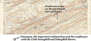
English: Most of the 7 minute and 30 second run westwardly of Panther Creek in Northeastern Pennsylvania from its rising on Mount Pisgah above but on the opposite slope from both Nesquehoning, Pennsylvania and Jim Thorpe, PA, thence running westerly between Pisgah Ridge (south) and Nesquehoning Ridge (north ridgeline) to its confluence in Tamaqua, Pennsylvania (just off the map to the lower left) with the Little Schuylkill River and its nearly co-located confluence with the Schuylkill River. |
||||||
| Date | |||||||
| Source | USGS,_Hazelton Quadrant 1893 survey | ||||||
| Author | USGS, as adapted by FrankB | ||||||
| Permission (Reusing this file) |
|
||||||
| Other versions | See Category:Northeastern Pennsylvania Topomaps, USGS MRC40075-series of (corners:N40xW75 to N41xW76) | ||||||

Licensing edit
| I, the copyright holder of this work, release this work into the public domain. This applies worldwide. In some countries this may not be legally possible; if so: I grant anyone the right to use this work for any purpose, without any conditions, unless such conditions are required by law. |
File history
Click on a date/time to view the file as it appeared at that time.
| Date/Time | Thumbnail | Dimensions | User | Comment | |
|---|---|---|---|---|---|
| current | 00:48, 4 October 2013 | | 813 × 370 (95 KB) | Fabartus (talk | contribs) | User created page with UploadWizard |
You cannot overwrite this file.
File usage on Commons
There are no pages that use this file.
File usage on other wikis
The following other wikis use this file:
- Usage on en.wikipedia.org
- Usage on www.wikidata.org