File:PankeStraßeNatur.JPG

Size of this preview: 750 × 600 pixels. Other resolutions: 300 × 240 pixels | 600 × 480 pixels | 960 × 768 pixels | 1,280 × 1,024 pixels | 1,600 × 1,280 pixels.
Original file (1,600 × 1,280 pixels, file size: 414 KB, MIME type: image/jpeg)
Captions
Captions
Add a one-line explanation of what this file represents
Summary
edit
| Camera location | | View this and other nearby images on: OpenStreetMap |
|---|
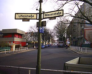
| Description | Nur noch Straßenschilder zeugen vom alten Umfeld der Panke |
| Date | |
| Source | Own work |
| Author | Boonekamp |
Licensing
edit
| I, the copyright holder of this work, release this work into the public domain. This applies worldwide. In some countries this may not be legally possible; if so: I grant anyone the right to use this work for any purpose, without any conditions, unless such conditions are required by law. |
File history
Click on a date/time to view the file as it appeared at that time.
| Date/Time | Thumbnail | Dimensions | User | Comment | |
|---|---|---|---|---|---|
| current | 19:39, 16 June 2009 | | 1,600 × 1,280 (414 KB) | Boonekamp (talk | contribs) | Verbesserung im Straßenschild |
| 19:33, 16 June 2009 |  | 1,600 × 1,280 (414 KB) | Boonekamp (talk | contribs) | Bevor ein besseres Bild bei blauerem Himmel vorliegt erstmal das Straßenschild ausgebessert. | |
| 17:06, 2 March 2008 |  | 1,600 × 1,280 (464 KB) | Boonekamp (talk | contribs) | == Beschreibung == {{location|52|32|56|N|13|22|20|E|region:DE-BE_heading:015}} {{Information |Description=Nur noch Straßenschilder zeugen vom alten Umfeld der Panke |Source=eigene Arbeit |Date=2008-02-24 |Author= Boonekamp |Permission= |
You cannot overwrite this file.
File usage on Commons
The following page uses this file:
File usage on other wikis
The following other wikis use this file:
- Usage on de.wikipedia.org