File:Parkfieldcapos.jpg

Original file (1,170 × 1,191 pixels, file size: 955 KB, MIME type: image/jpeg)
Captions
Captions
Summary edit
| DescriptionParkfieldcapos.jpg |
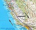
Deutsch: Topographische Karte des US-Bundesstaates Kalifornien mit Verzeichnung der San-Andreas-Verwerfung (violette Linien) nebst wichtigster Nebenäste und hervorgehobener Position der Ortschaft Parkfield, die eine besondere Rolle bei der Erforschung der San-Andreas-Verwerfung spielt.
English: Topographic map of the US state of California including the San Andreas Fault plus its main branches (violet lines) as well a the position of the small village of Parkfield, CA, which plays a special role in the San Andreas Fault research. |
| Date |
|
| Source |
|
| Author |
|
Licensing edit
| This file is made available under the Creative Commons CC0 1.0 Universal Public Domain Dedication. | |
| The person who associated a work with this deed has dedicated the work to the public domain by waiving all of their rights to the work worldwide under copyright law, including all related and neighboring rights, to the extent allowed by law. You can copy, modify, distribute and perform the work, even for commercial purposes, all without asking permission.
http://creativecommons.org/publicdomain/zero/1.0/deed.enCC0Creative Commons Zero, Public Domain Dedicationfalsefalse |
File history
Click on a date/time to view the file as it appeared at that time.
| Date/Time | Thumbnail | Dimensions | User | Comment | |
|---|---|---|---|---|---|
| current | 22:58, 24 May 2019 |  | 1,170 × 1,191 (955 KB) | Gretarsson (talk | contribs) | larger and much better resoluted file with complete extent of San Andreas Fault plus some of its major fault branches, according to https://earthquake.usgs.gov/learn/topics/safz-paleo/images/camap.gif |
| 20:23, 29 June 2006 |  | 850 × 713 (79 KB) | SMi (talk | contribs) | == Beschreibung == * Bildbeschreibung: Ausschnitt der Referenzkarte des US-Bundesstaates Kalifornien mit hervorgehobener Position der Ortschaft Parkfield, nachbearbeitet von mir selbst (so1eda) * Quelle: [http://de.wikipedia.org/wiki/Kalifornien Wikip |
You cannot overwrite this file.
File usage on Commons
There are no pages that use this file.
File usage on other wikis
The following other wikis use this file:
- Usage on de.wikipedia.org
Metadata
This file contains additional information such as Exif metadata which may have been added by the digital camera, scanner, or software program used to create or digitize it. If the file has been modified from its original state, some details such as the timestamp may not fully reflect those of the original file. The timestamp is only as accurate as the clock in the camera, and it may be completely wrong.
| Orientation | Normal |
|---|---|
| Horizontal resolution | 300 dpi |
| Vertical resolution | 300 dpi |
| Software used | Adobe Photoshop CS Windows |
| File change date and time | 00:46, 25 May 2019 |
| Color space | sRGB |
| Image width | 1,170 px |
| Image height | 1,191 px |
| Date and time of digitizing | 01:46, 25 May 2019 |
| Date metadata was last modified | 01:46, 25 May 2019 |
| IIM version | 2 |