File:Pegalajar (1559) mapa del término municipal.png

Size of this preview: 800 × 450 pixels. Other resolutions: 320 × 180 pixels | 640 × 360 pixels | 1,024 × 576 pixels | 1,743 × 980 pixels.
Original file (1,743 × 980 pixels, file size: 3.26 MB, MIME type: image/png)
Captions
Captions
Add a one-line explanation of what this file represents
Summary
edit_mapa_del_t%C3%A9rmino_municipal.png&action=edit§ion=1)
| Description |
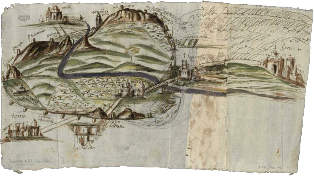
Español: Mapa del término municipal de Pegalajar (Provincia de Jaén - España) en 1559. Es la representación gráfica más antigua conocida de este pueblo; su objetivo era señalar los mojones que delimitaban el término con respecto a Cambil, Jaén, La Guardia, Mancha Real y Torres. Dibujo con aguada de autor desconocido, mide 32 x 57 cm. Documento depositado en el Archivo General de Simancas en Expedientes de Hacienda, legajo 356. M.P. y D. XLVIII-98; signatura IECA1989000174.[1] |
| Date | |
| Source | Juan Antonio López Cordero. Pegalajar. Cartografía histórica. En: Feria y Fiestas en honor a Ntra. Sra. Virgen de las Nieves, del 4 al 8 de agosto 2021. Pegalajar: Ayuntamiento de Pegalajar; 2021. p.24-27. |
| Author | Unknown author |
| Permission (Reusing this file) |
PD-art/1559 |
| Camera location | | View this and other nearby images on: OpenStreetMap |
|---|
_mapa_del_t%C3%A9rmino_municipal.png¶ms=037.738267_N_-003.650988_E_globe:Earth_type:camera__&language=en)
Referencias
edit_mapa_del_t%C3%A9rmino_municipal.png&action=edit§ion=2)
Licensing
edit_mapa_del_t%C3%A9rmino_municipal.png&action=edit§ion=3)
|
This work is in the public domain in its country of origin and other countries and areas where the copyright term is the author's life plus 100 years or fewer. | |
| This file has been identified as being free of known restrictions under copyright law, including all related and neighboring rights. | |
File history
Click on a date/time to view the file as it appeared at that time.
| Date/Time | Thumbnail | Dimensions | User | Comment | |
|---|---|---|---|---|---|
| current | 20:29, 24 August 2021 | | 1,743 × 980 (3.26 MB) | Raimundo Pastor (talk | contribs) | Uploaded a work by Desconocido from https://www.pegalajar.org/articulos/cartografia_pegalajar.pdf with UploadWizard |
You cannot overwrite this file.
File usage on Commons
The following 2 pages use this file:
File usage on other wikis
The following other wikis use this file:
- Usage on es.wikipedia.org
_mapa_del_término_municipal.png&oldid=857775920)