File:PikiWiki Israel 71775 central post office building.jpg

Original file (1,916 × 3,942 pixels, file size: 1.29 MB, MIME type: image/jpeg)
Captions
Captions
| Description |
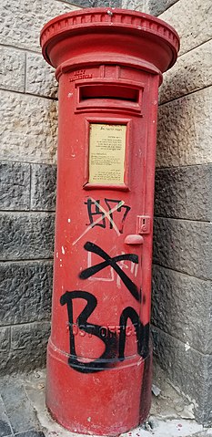
English: central Jerusalem, Coresh street (aka Koresh) behin Jerusalem's Central Post Office, British cast-iron pillar boxes in Jerusalem, dating from the British Mandate of Palestine. Until the State of Israel was created in 1948 there was a Royal cypher on the door of the pillar box; probably that of King George V. This was ground off after Israel gained independence.
עברית: בניין בית הדואר המרכזי ירושלים
Original Image Name: Piciwiki_israel_71775_20200914_180801_2_2.jpg Notes: מבנה משנת 1938 בין הרחובות יפו 23 לכורש הבנוי בסגנונות הבינלאומי והירושלמי המסורתי בחזיתו ורמז לממלוכי בגבו. זהו בניין מלבני בעל אגף אמצעי ושני אגפי צד זהים. דלתות הכניסה החלונות והאשנבים למכירת בולים תוי-דואר מצויים בתוך קשתות ובחלון המרכזי יש שעונים בחוץ ובפנים. בחזית למטה הציפוי באבן שחורה ומעל - באבן לבנה. בגב הבניין הציפוי באבן לבנה ושחורה לסירוגין. באולם המרכזי יש ציור קיר משנת 1972 של אברהם אופק 1935-1990. אורכו 27 מטרים והוא מתאר את החלוצים בראשית המאה ה- 20 ואת התפתחות ירושלים. Location: יפו 23 ירושלים |
| Date | |
| Source | Heritage Conservation Jerusalem via the PikiWiki - Israel free image collection project |
| Author | אושרה דיין |
| Permission (Reusing this file) |
This file is licensed under the Creative Commons Attribution 2.5 Generic license. Attribution: Heritage Conservation Jerusalem Pikiwiki Israel
|
| Other versions |
|


| Camera location | | View this and other nearby images on: OpenStreetMap |
|---|

|
This file has been submitted through the Israeli Pikiwiki project and uploaded here automatically.
The project is cooperation between the Israel Internet Association and Wikimedia Israel in an effort to promote the concept of free content on the Web, by creating an image collection of digital-format, good quality photographs, documenting events relating to the history of Israel, or depicting places of distinction in Israel and the Middle East. The Pikiwiki Project is managed from 2021 by the "Heritage Stones" group.
Please consider notifying the project before renaming or deleting this file. Further information about the project can be found on the commons-l mailing list.
|
File history
Click on a date/time to view the file as it appeared at that time.
| Date/Time | Thumbnail | Dimensions | User | Comment | |
|---|---|---|---|---|---|
| current | 01:26, 21 September 2020 | | 1,916 × 3,942 (1.29 MB) | Pikiwikisrael (talk | contribs) |
You cannot overwrite this file.
File usage on Commons
The following 2 pages use this file: