File:PikiWiki Israel 76549 ariel sharon park.jpg
![File:PikiWiki Israel 76549 ariel sharon park.jpg](https://upload.wikimedia.org/wikipedia/commons/thumb/0/08/PikiWiki_Israel_76549_ariel_sharon_park.jpg/800px-PikiWiki_Israel_76549_ariel_sharon_park.jpg?20210319012615)
Original file (4,032 × 1,960 pixels, file size: 1.97 MB, MIME type: image/jpeg)
Captions
Captions
DescriptionPikiWiki Israel 76549 ariel sharon park.jpg |
English: Ariel Sharon Park עברית: פארק אריאל שרון
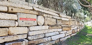
Original Image Name: Piciwiki_israel_76549_20210305_125227jpg Notes: שטח פתוח תחום עלידי תל אביביפו רמתגן אור יהודה ואזור משמש ריאה ירוקה של דרום גוש דן ב 1952 הוקם כאן אתר סילוק פסולת של גוש דן חירייה על שם הכפר הערבי אלחירייה הסמוך שנעזב במלחמת העצמאות הפסולת הגיעה לגובה של 60 מ ולרוחב של 544 מ ויצרה מפגעים סביבתיים כמו שחפים שסיכנו מטוסים שהמריאו ונחתו בנתבג הסמוך שריפות וגזים רעילים זיהום נחל איילון וצחנה החל מ 1998 החליף אתר דודאים בדרום את אתר חירייה הר הפסולת שוקם הפך לפארק ונפתח לציבור ב 2007 אך נגיש רק למגיעים בתחבורה פרטית Location: פארק אריאל שרון כביש 4 מחלף גנות |
Date | 5.3.2021 |
Source | oshra dayan via the PikiWiki - Israel free image collection project |
Author | אושרה דיין |
Permission (Reusing this file) |
![]() ![]() This file is licensed under the Creative Commons Attribution 2.5 Generic license. Attribution: oshra dayan Pikiwiki Israel
|
![]() |
This file has been submitted through the Israeli Pikiwiki project and uploaded here automatically.
The project is cooperation between the Israel Internet Association and Wikimedia Israel in an effort to promote the concept of free content on the Web, by creating an image collection of digital-format, good quality photographs, documenting events relating to the history of Israel, or depicting places of distinction in Israel and the Middle East. The Pikiwiki Project is managed from 2021 by the "Heritage Stones" group.
Please consider notifying the project before renaming or deleting this file. Further information about the project can be found on the commons-l mailing list.
|
![]() |
File history
Click on a date/time to view the file as it appeared at that time.
Date/Time | Thumbnail | Dimensions | User | Comment | |
---|---|---|---|---|---|
current | 01:26, 19 March 2021 | ![]() | 4,032 × 1,960 (1.97 MB) | Pikiwikisrael (talk | contribs) |
You cannot overwrite this file.
File usage on Commons
The following page uses this file:
Metadata
This file contains additional information such as Exif metadata which may have been added by the digital camera, scanner, or software program used to create or digitize it. If the file has been modified from its original state, some details such as the timestamp may not fully reflect those of the original file. The timestamp is only as accurate as the clock in the camera, and it may be completely wrong.
Camera manufacturer | samsung |
---|---|
Camera model | SM-G955U |
Exposure time | 1/311 sec (0.0032154340836013) |
F-number | f/1.7 |
ISO speed rating | 50 |
Date and time of data generation | 12:52, 5 March 2021 |
Lens focal length | 4.25 mm |
User comments | JKJK0
ŒŒþUZÛ¯³¡¡ùŽKéPØf»gÿÿíÜÿÿÆÿÿ¨‘S¨ÿÿNÿÿ˜ßA"A"A"1"1" 1"1"A"0 ‘1"A"A"A"A"A"01"1"A"A"‘" !"1"‘A"Q3A"A"A"A"A"A"A"A"A"1"!" "A"A"Q3Q3A"Q3Q3A"A"A"A"A"1"!"!"!" P3Q3Q3Q3Q3Q3A"A"A"A"A"1"1"!"!"!"A"A"A"A"A"A"A"A"A"A"A"1"1"1"!"!"A"A"A"pppP3A"A"A"A"A"A"A"1"1"@"A"A"`pp`A"A"A"A"A"A"A"1"1"A"A"@"A"A"A"A"A"Q3A"A"Q3Q3Q3A"1"A"A"A"A"A"A"0A"A"A"A"A"Q3A"A"2wA"A"A"A"A"A"0A"A"@"@"Q3Q3@"1""wA"Q3Q3A"Q30@"@"@"00@"P3A"!""wQ3Q3P3A"A"@"@"0 0@" !"1"@"@"P3@"@"00‘‘ 1"‘"w"wA"Q3Q3‘‘@"@"A"0‘@"0!"!""w"wP3‘‘P3@"Q3Q3@"@"0‘‘!"!""w2w+þ~Ó<õ s,‡8±9°9°9°†°†°œ…â0Œ$À² "9-€-€rfÒ:Ò:Gá õ õ ª:Ð4¡ŠÚ¬wÒ‹FAFA ?q–(¡¡3FAFA(–¶ÿ vç“––¶ÿ vç“––Åÿv磕–Åÿv磖–zìÿvçã––zìÿvçÖ–zìÿvçÖ–yõÿýÿvçÖ–yõÿýÿvçÖ–yõÿýÿvçÖ–wîÿúÿvçÖ–wîÿúÿvçÖ–wîÿúÿvçÖ–LvçÖ–LvçÖ–LvçÖ–)èÿõÿvçÖ–)èÿõÿvçÖ–)èÿõÿvçÖ–CöÿvçÖ–CöÿvçÖ–CöÿvçÖ–ùÿvçÖ–ùÿvçÖ–ùÿvçÖ–-öÿvçÖ–-öÿvçÖ–-öÿvçÖ–_üÿúÿvçÖ–_üÿúÿvçÖ–_üÿúÿvç×–B úÿvç×–B úÿvç×–B úÿvçÖ–RvçÖ–RvçÖ–,ÿÿvçÖ–,ÿÿvçÖ–,ÿÿvç×–KûÿvçÖ¡úÐ ðäÐÄFAFA¡ççšç–ç’ç‘çççç‘ç’ç’ç”ç çœç˜ç–ç•ç–ç“ç’ççç‘ç“ç‘çŸçšç•ç”ç˜ç–ç–ç”ççç’çç’çŸçšç–ç”ç˜ç—ç˜ç”ç‘çç“ç’ç‘çžçšç•ç•ç”ç–ç–ç“ççç‘ç’ççç›ç™ç•ç”ç”ç’ç‘ççççç’çŸç›ç˜ç•ç“ç•ç‘ç‘çç‘ç’ç’ç’ç ˜çÿ®®®®‡I£ Ÿ1¡rà * Š==¡ Kxà à I 27ŸIîîîî¹ææN™ Nûÿÿÿ„ø9j „ 4 " † ½ Ú æ ù ó 3 ä ¿ ÷ P å ø ô K ð Ç | Ç ¡ ù ê þ Ñ Ö Î Œ ¬ ‹ é ~ å G Ê N ? ˜ / 9 L 2
9=ÿÿÿÿ-ÿÿÿÿÿÿÿ£ £ 2~ïÿÿÿ! Ü ?„íÿÿÿêÿÿÿíÿÿÿíÿÿÿ½ÿÿÿH Þÿÿÿ÷ îÿÿÿç j1i~P ¿ÿÿÿÇÿÿÿ+ ´ , =I??d*$6 +%ssdjagssuniqueidi`3<p`3ssmtfÿÿÿÿÿÿÿÿÿÿÿÿÿÿÿÿÿÿÿÿÿÿÿÿÿÿÿÿÿÿÿÿÿÿÿÿÿÿÿÿÿÿÿÿÿÿÿÿÿÿÿÿÿÿSSCAL PF12QSKC0222401FFC1FC1S12ssoisD84KA02 D84KA02 D84KA02 0 |
Latitude | 0° 0′ 0″ N |
Longitude | 0° 0′ 0″ E |
Altitude | 0 meters above sea level |
Width | 4,032 px |
Height | 1,960 px |
Orientation | Normal |
Horizontal resolution | 72 dpi |
Vertical resolution | 72 dpi |
Software used | G955USQS8DTJ3 |
File change date and time | 12:52, 5 March 2021 |
Y and C positioning | Centered |
Exposure Program | Normal program |
Exif version | 2.2 |
Date and time of digitizing | 12:52, 5 March 2021 |
Meaning of each component |
|
APEX shutter speed | 8.28 |
APEX aperture | 1.53 |
APEX brightness | 5.62 |
APEX exposure bias | 0 |
Maximum land aperture | 1.53 APEX (f/1.7) |
Metering mode | Center weighted average |
Light source | Unknown |
Flash | Flash did not fire |
Supported Flashpix version | 1 |
Color space | sRGB |
Sensing method | One-chip color area sensor |
Scene type | A directly photographed image |
Exposure mode | Auto exposure |
White balance | Auto white balance |
Focal length in 35 mm film | 26 mm |
Scene capture type | Standard |
Unique image ID | F12QSJA00SM F12QSKB01SB |
GPS time (atomic clock) | 10:52 |
GPS date | 5 March 2021 |
GPS tag version | 0.0.2.2 |