File:PlanLignedeCabariotauChapus1910.jpg

Size of this preview: 800 × 466 pixels. Other resolutions: 320 × 187 pixels | 640 × 373 pixels | 1,024 × 597 pixels | 1,280 × 746 pixels | 2,199 × 1,282 pixels.
Original file (2,199 × 1,282 pixels, file size: 566 KB, MIME type: image/jpeg)
Captions
Captions
Add a one-line explanation of what this file represents
Summary
edit
| Description |
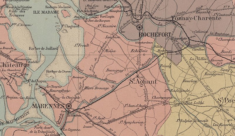
Français : Extrait de la Carte du département de la Charente-Inférieure / dressée par E. Lacroix ; ingénieur civil, mise à jour par J. Charrier, conducteur des ponts et chaussées... 1910 , montrant le tracé de la ligne de chemin de fer de Cabariot au Chapus. |
| Date | |
| Source | https://gallica.bnf.fr/ark:/12148/btv1b53063603q?rk=1695287;2 |
| Author | auteurs : E. Lacroix et J. Charrier ; éditeur A. Roufineau |
Licensing
edit
| This file is made available under the Creative Commons CC0 1.0 Universal Public Domain Dedication. | |
| The person who associated a work with this deed has dedicated the work to the public domain by waiving all of their rights to the work worldwide under copyright law, including all related and neighboring rights, to the extent allowed by law. You can copy, modify, distribute and perform the work, even for commercial purposes, all without asking permission.
|
File history
Click on a date/time to view the file as it appeared at that time.
| Date/Time | Thumbnail | Dimensions | User | Comment | |
|---|---|---|---|---|---|
| current | 06:16, 24 January 2020 | | 2,199 × 1,282 (566 KB) | Quoique (talk | contribs) | User created page with UploadWizard |
You cannot overwrite this file.
File usage on Commons
There are no pages that use this file.
File usage on other wikis
The following other wikis use this file:
- Usage on fr.wikipedia.org