File:Plattegrond van Schoonhoven, ca. 1701-1715 Schoonhoven (titel op object), RP-T-00-3661A-2.jpg
Size of this preview: 770 × 600 pixels. Other resolutions: 308 × 240 pixels | 616 × 480 pixels | 986 × 768 pixels | 1,280 × 997 pixels | 2,560 × 1,994 pixels | 5,338 × 4,158 pixels.
Original file (5,338 × 4,158 pixels, file size: 2.4 MB, MIME type: image/jpeg)
Captions
Captions
Add a one-line explanation of what this file represents
Summary
edit,_RP-T-00-3661A-2.jpg&action=edit§ion=1)
| Description |
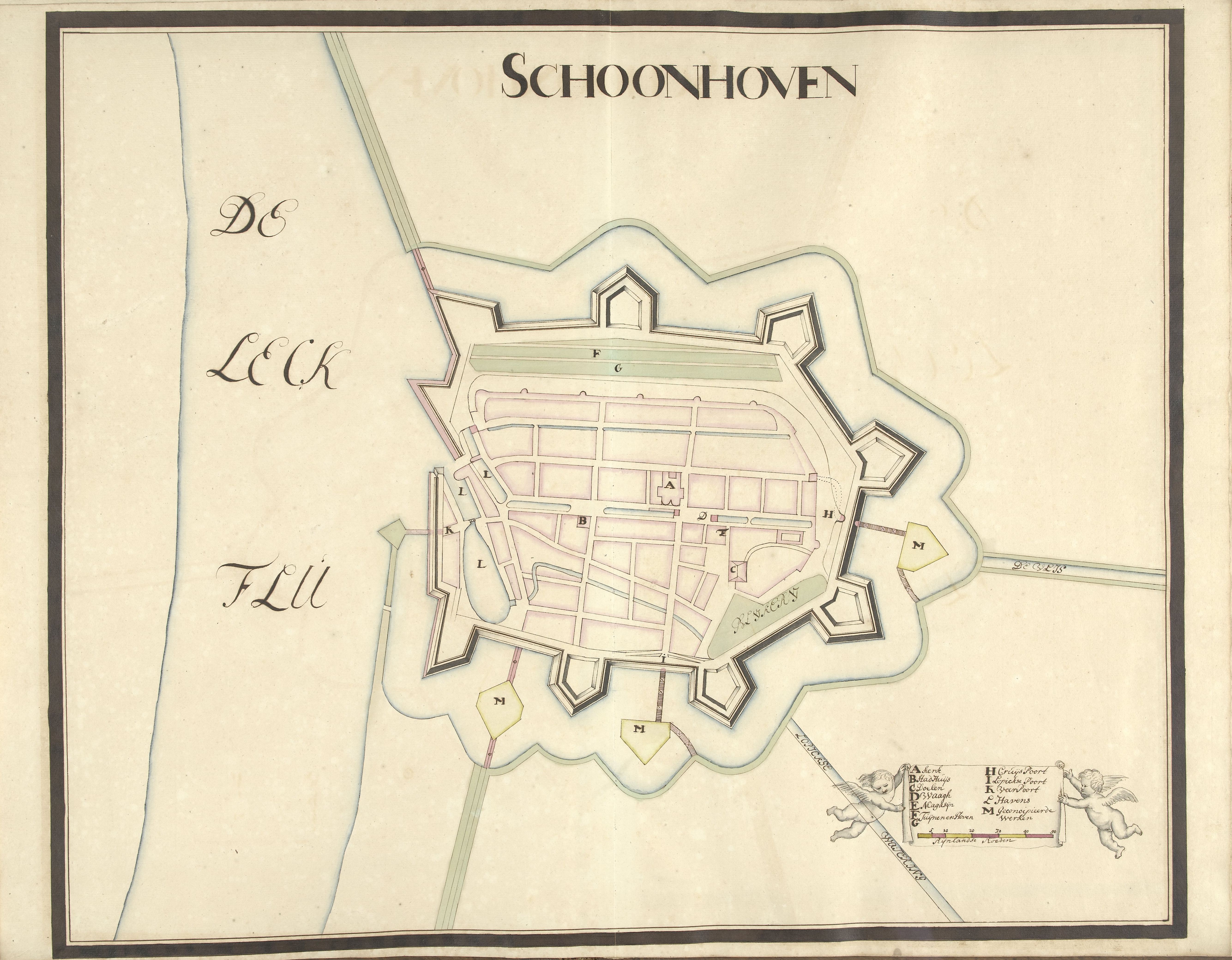
Nederlands: Identificatie Titel(s): Plattegrond van Schoonhoven, ca. 1701-1715. Schoonhoven (titel op object) Objecttype: tekening kaart Objectnummer: RP-T-00-3661. A-2 Catalogusreferentie: FMH 3036-A/2 Omschrijving: Plattegrond van de versterkingen om de stad Schoonhoven, ca. 1701-1715. Rechtsonder een cartouche met de legenda A-M in het Nederlands, opgehouden door twee putti. Onderdeel van een verzameling getekende plannen van versterkte plaatsen in Nederland en omringende landen ten tijde van de Spaanse Successieoorlog (deel A). Vervaardiging Vervaardiger: tekenaar: Samuel Du Ry de Champdoré Plaats vervaardiging: Nederland Datering: 1701 - 1715 Fysieke kenmerken: pen in bruin, penseel in kleuren Materiaal: papier Afmetingen: blad: h 482 mm × b 616 mm Onderwerp Wat: maps of citiesfortress. Spaanse Successieoorlog Wanneer: 1701 - 1713 Waar: Schoonhoven Verwerving en rechten Verwerving: aankoop 1881 Copyright: Publiek domein |
| Date | between 1701 and 1715 |
| Source | http://hdl.handle.net/10934/RM0001.COLLECT.476789 |
| Author | Rijksmuseum |
Licensing
edit,_RP-T-00-3661A-2.jpg&action=edit§ion=2)
| This file is made available under the Creative Commons CC0 1.0 Universal Public Domain Dedication. | |
| The person who associated a work with this deed has dedicated the work to the public domain by waiving all of their rights to the work worldwide under copyright law, including all related and neighboring rights, to the extent allowed by law. You can copy, modify, distribute and perform the work, even for commercial purposes, all without asking permission.
|
File history
Click on a date/time to view the file as it appeared at that time.
| Date/Time | Thumbnail | Dimensions | User | Comment | |
|---|---|---|---|---|---|
| current | 14:54, 18 January 2020 | | 5,338 × 4,158 (2.4 MB) | Mr.Nostalgic (talk | contribs) | == {{int:filedesc}} == {{Information |Description={{nl|1=<br><br><big>'''Identificatie'''</big><br>'''Titel(s): '''Plattegrond van Schoonhoven, ca. 1701-1715Schoonhoven (titel op object)<br>'''Objecttype:''' tekening kaart <br>'''Objectnummer:''' RP-T-00-3661A-2<br>'''Catalogusreferentie:''' FMH 3036-A/2<br>'''Omschrijving:''' Plattegrond van de versterkingen om de stad Schoonhoven, ca. 1701-1715. Rechtsonder een cartouche met de legenda A-M in het Nederlands, opgehouden door twee putti. Onde... |
You cannot overwrite this file.
File usage on Commons
There are no pages that use this file.
,_RP-T-00-3661A-2.jpg&oldid=841798776)