File:Plattegrond van Venlo Venloo (titel op object), BI-B-FM-090-163.jpg

Size of this preview: 800 × 575 pixels. Other resolutions: 320 × 230 pixels | 640 × 460 pixels | 1,024 × 736 pixels | 1,280 × 920 pixels | 2,560 × 1,840 pixels | 3,748 × 2,694 pixels.
Original file (3,748 × 2,694 pixels, file size: 1.36 MB, MIME type: image/jpeg)
Captions
Captions
Add a one-line explanation of what this file represents
Summary edit
,_BI-B-FM-090-163.jpg&action=edit§ion=1)
| Description |
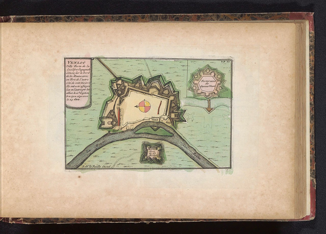
Nederlands: Identificatie Titel(s): Plattegrond van Venlo. Venloo (titel op object) Objecttype: prent kaart Objectnummer: BI-B-FM-090-163 Catalogusreferentie: FMH 3750-a/163 Omschrijving: Plattegrond van de versterkingen om de stad Venlo en de forten Stevensweert en Sint-Michiel. Onderdeel van een atlas met 223 kaarten van landen en steden en oorlogstaferelen in Europa in de periode ca. 1690-1735. Vervaardiging Vervaardiger: prentmaker: anoniem, uitgever: erven J. Ratelband & Co, uitgever: Daniel de Lafeuille (vermeld op object) Plaats vervaardiging: prentmaker: Noordelijke Nederlanden, uitgever: Amsterdam, uitgever: Amsterdam Datering: 1700 - 1702 en/of 1735 Fysieke kenmerken: ets, met de hand gekleurd en deels gelakt Materiaal: papier Techniek: etsen / met de hand kleuren / lakken Afmetingen: plaatrand: h 117 mm × b 176 mm Onderwerp Wat: maps of citiesfortressfortified city Wanneer: 1690 - 1735 Waar: Venlo. Stevensweert. Fort Sint-Michiel Verwerving en rechten Verwerving: aankoop 1881 Copyright: Publiek domein |
| Date | - 1702 en/of 1735 |
| Source | http://hdl.handle.net/10934/RM0001.COLLECT.504901 |
| Author | Rijksmuseum |
Licensing edit
,_BI-B-FM-090-163.jpg&action=edit§ion=2)
| This file is made available under the Creative Commons CC0 1.0 Universal Public Domain Dedication. | |
| The person who associated a work with this deed has dedicated the work to the public domain by waiving all of their rights to the work worldwide under copyright law, including all related and neighboring rights, to the extent allowed by law. You can copy, modify, distribute and perform the work, even for commercial purposes, all without asking permission.
|
File history
Click on a date/time to view the file as it appeared at that time.
| Date/Time | Thumbnail | Dimensions | User | Comment | |
|---|---|---|---|---|---|
| current | 07:26, 29 November 2019 | | 3,748 × 2,694 (1.36 MB) | Mr.Nostalgic (talk | contribs) | == {{int:filedesc}} == {{Information |Description={{nl|1=<br><br><big>'''Identificatie'''</big><br>'''Titel(s): '''Plattegrond van VenloVenloo (titel op object)<br>'''Objecttype:''' prent kaart <br>'''Objectnummer:''' BI-B-FM-090-163<br>'''Catalogusreferentie:''' FMH 3750-a/163<br>'''Omschrijving:''' Plattegrond van de versterkingen om de stad Venlo en de forten Stevensweert en Sint-Michiel. Onderdeel van een atlas met 223 kaarten van landen en steden en oorlogstaferelen in Europa in de perio... |
You cannot overwrite this file.
File usage on Commons
There are no pages that use this file.
,_BI-B-FM-090-163.jpg&oldid=876675284)