File:Quinta Europa Tabula 1520 (alt).jpg

Size of this preview: 800 × 517 pixels. Other resolutions: 320 × 207 pixels | 640 × 413 pixels | 1,024 × 661 pixels | 1,280 × 827 pixels | 2,560 × 1,653 pixels | 5,000 × 3,229 pixels.
Original file (5,000 × 3,229 pixels, file size: 5.16 MB, MIME type: image/jpeg)
Captions
Captions
Add a one-line explanation of what this file represents
Summary edit
.jpg&action=edit§ion=1)
| Description |
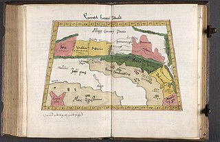
Latina: Quinta Europa Tabula. |
| Date | |
| Source | the-fifth-map-of-europe-quinta-europae-tabula-peter-freilaender/_QHHJAk7SZxOzQ — Google Arts & Culture |
| Author | Peter Freiländer |
Licensing edit
.jpg&action=edit§ion=2)
|
This work is in the public domain in its country of origin and other countries and areas where the copyright term is the author's life plus 100 years or fewer. | |
| This file has been identified as being free of known restrictions under copyright law, including all related and neighboring rights. | |
File history
Click on a date/time to view the file as it appeared at that time.
| Date/Time | Thumbnail | Dimensions | User | Comment | |
|---|---|---|---|---|---|
| current | 09:00, 6 November 2019 | | 5,000 × 3,229 (5.16 MB) | Sporti (talk | contribs) | =={{int:filedesc}}== {{Information |description={{la|Quinta Europa Tabula.}} |date=1520 |source=https://artsandculture.google.com/asset/the-fifth-map-of-europe-quinta-europae-tabula-peter-freilaender/_QHHJAk7SZxOzQ |author=Peter Freiländer }} =={{int:license-header}}== {{PD-old-100}} Category:16th-century maps of Slovenia Category:1520 maps Category:Maps in Latin 1520 [[Category:Google Art Project works in National and University Library o... |
You cannot overwrite this file.
File usage on Commons
The following 2 pages use this file:
.jpg&oldid=724430632)