File:Región Centro de Argentina.png

Size of this preview: 363 × 599 pixels. Other resolutions: 145 × 240 pixels | 568 × 937 pixels.
Original file (568 × 937 pixels, file size: 19 KB, MIME type: image/png)
Captions
Captions
Add a one-line explanation of what this file represents
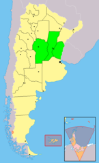
| Description | Mapa de Argentina señalando en verde las provincias integrantes de la Región Centro: Córdoba, Santa Fe y Entre Ríos |
| Date | |
| Source | Trabajo propio a partir de Image:Argentina - Político.png |
| Author | Trabajo propio |
| Permission (Reusing this file) |
Modificación de Image:Argentina - Político.png, se aplica la misma licencia |
| Other versions | 100px |
I, the copyright holder of this work, hereby publish it under the following licenses:

|
Permission is granted to copy, distribute and/or modify this document under the terms of the GNU Free Documentation License, Version 1.2 or any later version published by the Free Software Foundation; with no Invariant Sections, no Front-Cover Texts, and no Back-Cover Texts. A copy of the license is included in the section entitled GNU Free Documentation License. |
| This file is licensed under the Creative Commons Attribution-Share Alike 3.0 Unported license. | ||
| ||
| This licensing tag was added to this file as part of the GFDL licensing update. |
You may select the license of your choice.
File history
Click on a date/time to view the file as it appeared at that time.
| Date/Time | Thumbnail | Dimensions | User | Comment | |
|---|---|---|---|---|---|
| current | 23:36, 28 April 2018 | | 568 × 937 (19 KB) | Janitoalevic (talk | contribs) | . |
| 14:50, 26 April 2008 |  | 568 × 937 (36 KB) | Cambalachero (talk | contribs) | {{Information |Description= Mapa de Argentina señalando en verde las provincias integrantes de la Región Centro: Córdoba, Santa Fe y Entre Ríos |Source= Trabajo propio a partir de Image:Argentina - Político.png |Date= 26/04/2008 |Author= Trabajo |
You cannot overwrite this file.
File usage on Commons
There are no pages that use this file.
File usage on other wikis
The following other wikis use this file:
- Usage on de.wikipedia.org
- Usage on eo.wikipedia.org
- Usage on es.wikipedia.org
- Usage on eu.wikipedia.org
- Usage on fr.wikipedia.org