File:Reichenau an der Rax - Schloss Rothschild.JPG

Size of this preview: 800 × 533 pixels. Other resolutions: 320 × 213 pixels | 640 × 427 pixels | 1,024 × 683 pixels | 1,280 × 853 pixels | 2,560 × 1,707 pixels | 4,200 × 2,800 pixels.
Original file (4,200 × 2,800 pixels, file size: 9.81 MB, MIME type: image/jpeg)
Captions
Captions
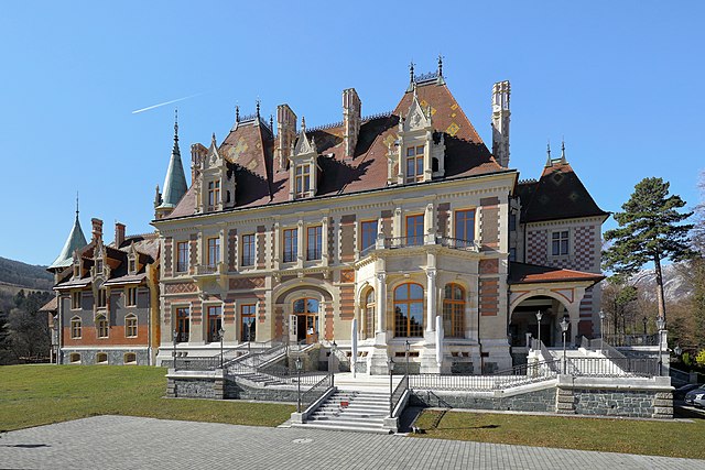
Rothschild Castle in Reichenau an der Rax, Lower Austria.
Summary
edit| Description |
Deutsch: Nordostansicht des Schlosses Rothschild, auch als Schloss Hinterleiten bezeichnet, in Hinterleiten, ein Ortsteil der niederösterreichischen Marktgemeinde Reichenau an der Rax.
Der repräsentative Landsitz wurde von 1884 bis 1889 nach Plänen der Architekten Architekten Amand Louis Bauqué und Albert Emilio Pio im Auftrag von Nathaniel Meyer Freiherr von Rothschild von Heinrich Glaser errichtet, jedoch nicht vollständig fertiggestellt. 1894 erfolgte die Stiftung für invalide Offiziere und 1900 wurde es dem k.u.k. Kriegsministerium als Stiftungsbehörde übergeben. Seit 1958 ist es im Besitz der „Vereinigte Altösterreichische Militärstiftungen“, die es seit 1993 teilweise dem Bundesheer als Schulungszentrum vermietet. English: Northeast view of Rothschild Castle in Reichenau an der Rax, Lower Austria. |
| Date | |
| Source | Own work |
| Author | C.Stadler/Bwag |
| Permission (Reusing this file) |
Deutsch: Hallo, du darfst mein Foto kostenlos nutzen, aber nenne mich bitte als Fotograf, beispielsweise „Foto: C.Stadler/Bwag“ oder © C.Stadler/Bwag; CC-BY-SA-4.0. Auf mehr Angaben bestehe ich nicht - im Gegensatz zu manch anderen, die die Vorgaben der unten angeführten Lizenzierung auf Punkt und Beistrich einfordern. English: Feel free to use my photos, but please mention me as the author like © C.Stadler/Bwag or © C.Stadler/Bwag; CC-BY-SA-4.0 (that's good enough) and if you want send me a message: bwag@gmx.net. |
| Other versions |
|
.JPG)
| Object location | | View this and other nearby images on: OpenStreetMap |
|---|
| Camera location | | View this and other nearby images on: OpenStreetMap |
|---|
Licensing
edit
I, the copyright holder of this work, hereby publish it under the following license:
This file is licensed under the Creative Commons Attribution-Share Alike 4.0 International license.
- You are free:
- to share – to copy, distribute and transmit the work
- to remix – to adapt the work
- Under the following conditions:
- attribution – You must give appropriate credit, provide a link to the license, and indicate if changes were made. You may do so in any reasonable manner, but not in any way that suggests the licensor endorses you or your use.
- share alike – If you remix, transform, or build upon the material, you must distribute your contributions under the same or compatible license as the original.
File history
Click on a date/time to view the file as it appeared at that time.
| Date/Time | Thumbnail | Dimensions | User | Comment | |
|---|---|---|---|---|---|
| current | 21:21, 4 March 2021 | | 4,200 × 2,800 (9.81 MB) | Bwag (talk | contribs) | {{Information |Description= {{de|1= Nordostansicht des Schlosses Rothschild, auch als ''Schloss Hinterleiten'' bezeichnet, in Hinterleiten, ein Ortsteil der niederösterreichischen Marktgemeinde Reichenau an der Rax.<br/>.Der repräsentative Landsitz wurde von 1884 bis 1889 nach Plänen der Architekten Architekten Amand Louis Bauqué und Albert Emilio Pio im Auftrag von Nathaniel Meyer Freiherr von Rothschild von Heinrich Glaser errichtet, jedoch nicht vollständig fertiggestellt. 1894 erfolgte d... |
You cannot overwrite this file.
File usage on Commons
The following 3 pages use this file:
File usage on other wikis
The following other wikis use this file:
- Usage on de.wikipedia.org
- Usage on en.wikipedia.org
- Usage on eo.wikipedia.org
- Usage on fr.wikipedia.org
- Usage on hy.wikipedia.org
- Usage on ms.wikipedia.org
- Usage on ru.wikipedia.org
- Usage on www.wikidata.org
- Usage on zh.wikipedia.org