File:Round Tower - standing alongside Bruce Castle.jpg

Original file (2,600 × 3,890 pixels, file size: 2.3 MB, MIME type: image/jpeg)
Captions
Captions
Summary
edit
| Description |
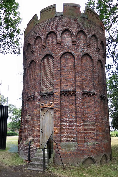
English: Text below from Haringey Council website about Bruce Castle. (Accessed 7 July 2018.)
"The Round Tower was built at this time, [around 1514] constructed of narrow red bricks, made from local clay. The main fabric of the tower is made up of original Tudor bricks. Its walls are three feet thick. Nearby, at the original Tottenham parish church of All Hallows, the Tudor porch has similar moulded or ‘castellated’ brick ornament. The original purpose of the Round Tower is unknown. Current belief is that it may have been used for falconry as a ‘hawks mews’ (a place to rear young birds for hunting). In 1705, the 2nd Lord Coleraine was writing about the history of Tottenham. Even he knew nothing about the tower, saying: ‘... in respect of its great antiquity more than conveniency, I keep the old brick tower in good repair, although I am not able to discover the founder thereof’’. _____________ I've walked past the tower many times. But taking a new photo and re-reading this quote I wondered: 'How can that be?' We have a 16th Century Tudor tower built next to a former Manor House. (Not a castle, by the way.) But by the beginning of the 18th Century it seems there was no record of who built it, or its purpose. "Lord" Coleraine's explanation - that he kept it in repair because it was very old, makes good business sense. In the 18th Century follies were fashionable. For the late 20th Century a posh theory was favoured: Falconry "a status symbol among the nobles of medieval Europe". Other less aristocratic possible explanations are not put forward. _____________ § Bruce Castle with Google Street View. § In summer 2006 Bruce Castle Museum worked with The Museum of London and and dozens of young volunteers to excavate close to the tower. § In 2007 the London Archaeological Archive and Research Centre (LAARC) posted photos of the dig and some of the objects found. |
| Date | |
| Source | https://www.flickr.com/photos/53921762@N00/41436609240/ |
| Author | Alan Stanton |
| Camera location | | View this and other nearby images on: OpenStreetMap |
|---|
Licensing
edit
- You are free:
- to share – to copy, distribute and transmit the work
- to remix – to adapt the work
- Under the following conditions:
- attribution – You must give appropriate credit, provide a link to the license, and indicate if changes were made. You may do so in any reasonable manner, but not in any way that suggests the licensor endorses you or your use.
- share alike – If you remix, transform, or build upon the material, you must distribute your contributions under the same or compatible license as the original.
| This image was originally posted to Flickr by Alan Stanton at https://flickr.com/photos/53921762@N00/41436609240. It was reviewed on 23 December 2021 by FlickreviewR 2 and was confirmed to be licensed under the terms of the cc-by-sa-2.0. |
File history
Click on a date/time to view the file as it appeared at that time.
| Date/Time | Thumbnail | Dimensions | User | Comment | |
|---|---|---|---|---|---|
| current | 06:02, 23 December 2021 | | 2,600 × 3,890 (2.3 MB) | Oxyman (talk | contribs) | Uploaded a work by Alan Stanton from https://www.flickr.com/photos/53921762@N00/41436609240/ with UploadWizard |
You cannot overwrite this file.
File usage on Commons
There are no pages that use this file.