File:SBB Historic - Von Norden her zum Gotthard 1950.pdf

Size of this JPG preview of this PDF file: 293 × 600 pixels. Other resolutions: 117 × 240 pixels | 234 × 480 pixels | 816 × 1,670 pixels.

Original file (816 × 1,670 pixels, file size: 6.61 MB, MIME type: application/pdf, 4 pages)
Captions
Captions
Add a one-line explanation of what this file represents
Summary edit
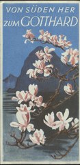
| Gotthard Streckenplan
( |
|||||||||||||||||||||
|---|---|---|---|---|---|---|---|---|---|---|---|---|---|---|---|---|---|---|---|---|---|
| Author |
Unknown author |
 | |||||||||||||||||||
| Title |
Gotthard Streckenplan |
||||||||||||||||||||
| Subtitle | Der detaillierte Plan der Strecke mit kleinen Illustrationen der Highlights und deren Standort auf der Karte führt auf der einen Seite des Prospektes von Norden nach Süden und auf der anderen Seite wieder zurück. Ein Längenprofil von Flüelen bis Faido und von Lavorgo bis Chiasso ergänzt die Karte. | ||||||||||||||||||||
| Publication date | between 1950 and 1952 | ||||||||||||||||||||
| Source |
|
||||||||||||||||||||
Licensing edit
This file is licensed under the Creative Commons Attribution-Share Alike 4.0 International license.
- You are free:
- to share – to copy, distribute and transmit the work
- to remix – to adapt the work
- Under the following conditions:
- attribution – You must give appropriate credit, provide a link to the license, and indicate if changes were made. You may do so in any reasonable manner, but not in any way that suggests the licensor endorses you or your use.
- share alike – If you remix, transform, or build upon the material, you must distribute your contributions under the same or compatible license as the original.
File history
Click on a date/time to view the file as it appeared at that time.
| Date/Time | Thumbnail | Dimensions | User | Comment | |
|---|---|---|---|---|---|
| current | 11:45, 2 July 2019 |  | 816 × 1,670, 4 pages (6.61 MB) | SBB Historic (talk | contribs) | pattypan 18.02 |
You cannot overwrite this file.
File usage on Commons
The following page uses this file: