File:Sandzak region map.png
Size of this preview: 628 × 600 pixels. Other resolutions: 251 × 240 pixels | 503 × 480 pixels | 974 × 930 pixels.
Original file (974 × 930 pixels, file size: 53 KB, MIME type: image/png)
Captions
Captions
Add a one-line explanation of what this file represents
Summary
edit
| Description |
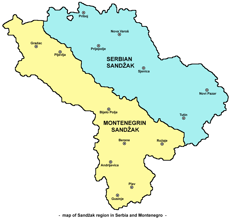
English: Map of Sandžak region in Serbia and Montenegro. Note: This map show Sandžak region in its largest geographical extent. According to some other views, Montenegrin municipalities of Plav and Andrijevica might not belong to Sandžak. Serbian / Montenegrin / Bosnian: Mapa Sandžaka u Srbiji i Crnoj Gori. Napomena: ova mapa prikazuje Sandžak u najvećem geografskom obimu. Prema drugim interpretacijama, crnogorske opštine Plav i Andrijevica ne spadaju u Sandžak. |
| Date | |
| Source | Own work |
| Author | PANONIAN |
| Other versions | Derivative works of this file: MapaDeLaDivisiónDelSanyakDeNoviPazar.svg |
References
edit
- Dr Tomislav Bogavac, Nestajanje Srba, Niš, 1994.
- http://www.bihor-petnica.com/Sandzak_Karta-zuta.gif
- http://www.bihor-petnica.com/sandzak-manja%20karta.jpg
- http://data36.sevenload.com/slcom/ww/mc/ciienk/eqzhjljbcdc.jpg
- http://www.radiosandzak.eu/FotoSandzaka/KartaSANDZAK.jpg
- http://www.bihor-petnica.com/Sandzak_u_Jugoslaviji.gif
- http://i1234.photobucket.com/albums/ff403/kedza1/BNV/PolozajSandzaka.jpg
- http://ligazasandzak.org/wp-content/uploads/2012/08/sandzak1.jpg
- http://sandzakbiznis.com/wordpress/sandzak.jpg
- http://api.ning.com/files/t7Mn40e4xGQfrLqZ9-1YGqqsl-TwYabCClIbqEOmuiBuVw7w1oO3KsZQzvrZF5gZPNhldyWJE-0zbOgJ9gXLQMezEgWVdtuV/Sandzakkartanova.jpg
- http://www.magasinetroest.dk/uploads/pics/Sandzak.jpg
- http://publishing.cdlib.org/ucpressebooks/data/13030/47/kt2k401947/figures/kt2k401947_fig003.gif
- http://t0.gstatic.com/images?q=tbn:ANd9GcQ1SPbXT6Y7H_F5h-sV6Fw0vOrnooACQtY3lyr_eZ4872CfvNnENA&t=1
- http://www.orbus.be/religion/islam/images/balkan-sandzak-300.jpg
- http://api.ning.com/files/aUR14cLVxZ6HUuLPtJyCnPRoHFWqnULDq4rRz3z-RnC2Ax5fZrFiilO-qrfofCtMn37ocGhe618*Ae8**Y7jI-IHym18ouA7/KartaSandzakaiSrbije.jpg
Licensing
edit
| I, the copyright holder of this work, release this work into the public domain. This applies worldwide. In some countries this may not be legally possible; if so: I grant anyone the right to use this work for any purpose, without any conditions, unless such conditions are required by law. |
File history
Click on a date/time to view the file as it appeared at that time.
| Date/Time | Thumbnail | Dimensions | User | Comment | |
|---|---|---|---|---|---|
| current | 09:14, 3 October 2009 | | 974 × 930 (53 KB) | PANONIAN (talk | contribs) | {{Information |Description={{en|1=Map of Sandžak region in Serbia and Montenegro. Note: This map show Sandžak region in its largest geographical extent. According to some other views, Montenegrin municipalities of Plav and Andrijevica might not belong t |
You cannot overwrite this file.
File usage on Commons
The following 3 pages use this file:
File usage on other wikis
The following other wikis use this file:
- Usage on ar.wikipedia.org
- Usage on bs.wikipedia.org
- Usage on ca.wikipedia.org
- Usage on de.wikipedia.org
- Usage on en.wikipedia.org
- Usage on es.wikipedia.org
- Usage on fr.wikipedia.org
- Usage on hr.wikipedia.org
- Usage on hu.wikipedia.org
- Usage on id.wikipedia.org
- Usage on it.wikipedia.org
- Usage on ja.wikipedia.org
- Usage on ko.wikipedia.org
- Usage on mk.wikipedia.org
- Usage on mn.wikipedia.org
- Usage on nl.wikipedia.org
- Usage on no.wikipedia.org
- Usage on pl.wikipedia.org
- Usage on pt.wikipedia.org
- Usage on ro.wikipedia.org
- Usage on sh.wikipedia.org
- Usage on sk.wikipedia.org
- Usage on sq.wikipedia.org
- Usage on tr.wikipedia.org
- Usage on uk.wikipedia.org
- Usage on zh.wikipedia.org
- Usage on zh.wikivoyage.org