File:Schmettau Blabbergraben mittlere Seen.jpg
Size of this preview: 591 × 599 pixels. Other resolutions: 237 × 240 pixels | 473 × 480 pixels | 758 × 768 pixels | 1,010 × 1,024 pixels | 1,312 × 1,330 pixels.
Original file (1,312 × 1,330 pixels, file size: 1.29 MB, MIME type: image/jpeg)
Captions
Captions
Add a one-line explanation of what this file represents
Summary edit
| Description |
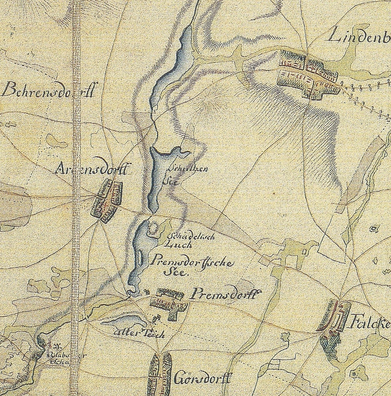
Deutsch: Ausschnitt aus dem Schmettauschen Kartenwerk von 1767/1787 im heutigen im Landkreis Oder-Spree in Brandenburg. Die Karte zeigt die Dörfer Lindenberg, Falkenberg und Görsdorf nebst Wohnplatz Premsdorf (heute sämtlich Ortsteile der Gemeinde Tauche) sowie Ahrensdorf (Ortsteil der Gemeinde Rietz-Neuendorf). Die Karte verzeichnet ferner den mittleren Teil des Blabbergrabens mit (von Nord nach Süd) Lindenberger See, Ahrensdorfer See (hier noch als Schultzen See bezeichnet), Premsdorfer See und Blabberschäferei.
English: Extract of a Schmettau map from 1767/1787 with a part of the today’s District Oder-Spree, Brandenburg, Germany. The map shows the villages Lindenberg, Falkenberg and Görsdorf with its part Premsdorf (today parts of the municipality Tauche) as well as Ahrensdorf (part of the municipality Rietz-Neuendorf). It also shows the central part of the Blabbergraben with (from north to south) Lindenberger lake, Ahrensdorfer lake (named here as Schultzen See), Premsdorfer lake and Blabberschäferei (former sheep). |
|||||||||||||||||||
| Date | between 1767 and 1787 | |||||||||||||||||||
| Source | Schmettausches Kartenwerk, 1:50.000, Blatt Brandenburg-Sektion 91, Franckfurth (1767–1787) | |||||||||||||||||||
| Author |
|
|||||||||||||||||||
Licensing edit
|
This is a faithful photographic reproduction of a two-dimensional, public domain work of art. The work of art itself is in the public domain for the following reason:
The official position taken by the Wikimedia Foundation is that "faithful reproductions of two-dimensional public domain works of art are public domain".
This photographic reproduction is therefore also considered to be in the public domain in the United States. In other jurisdictions, re-use of this content may be restricted; see Reuse of PD-Art photographs for details. | ||||
File history
Click on a date/time to view the file as it appeared at that time.
| Date/Time | Thumbnail | Dimensions | User | Comment | |
|---|---|---|---|---|---|
| current | 12:26, 25 October 2014 | | 1,312 × 1,330 (1.29 MB) | Lienhard Schulz (talk | contribs) | {{Information |description= {{de|Ausschnitt aus dem Schmettauschen Kartenwerk von 1767/1787 im heutigen im Landkreis Oder-Spree in Brandenburg. Die Karte zeigt die Dörfer [[:de:L... |
You cannot overwrite this file.
File usage on Commons
There are no pages that use this file.
File usage on other wikis
The following other wikis use this file:
- Usage on de.wikipedia.org