File:Seismic areas, Java - Kaliurang - UNESCO - PHOTO0000001874 0001.tiff

Size of this JPG preview of this TIF file: 461 × 600 pixels. Other resolutions: 184 × 240 pixels | 369 × 480 pixels | 590 × 768 pixels | 787 × 1,024 pixels | 1,574 × 2,048 pixels | 4,443 × 5,779 pixels.
Original file (4,443 × 5,779 pixels, file size: 73.74 MB, MIME type: image/tiff)
Captions
Captions
Add a one-line explanation of what this file represents
Summary edit
| Photographer |
Mattson |
|||||
| Description |
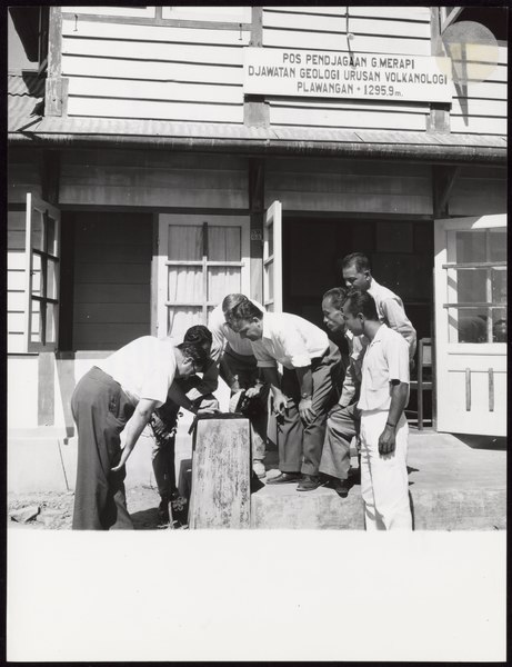
Français : Des hommes sont regroupés devant une maison en bois. Ils sont en train de lire un papier posé sur un poteau de bois. Sur la maison un panneau indique qu'il s'agit d'un centre de volcanologie |
|||||
| Depicted place | Java - Kaliurang, Indonesia (Q252) | |||||
| Keywords | Seismic areas, Seismological observatories, Seismology, Volcanic eruptions, Volcanoes, Experts, Earthquake prediction, | |||||
| Date | 1961 | |||||
| Accession number |
PHOTO0000001874 |
|||||
| Inscriptions |
English: At the request of the United Nations Economic and Social Council, UNESCO is sending missions of experts to the seismic belts of the world to study the existing state of seismological observations and mapping of seismic activity and the extent to which the possibility of earthquake damage is taken into account in the construction of building and civil engineering works. The first of these missions visited South East Asia during May to July 1961. Here, members of the mission study seismograms at the seismological station at Kaliurang, Centra Java (No. 22.689 shows, in the background, the Merapi Volcano which had erupted on May 9, 1961) Français : A la demande du Conseil économique et social des Nations Unies, l'UNESCO a envoyé des experts dans les régions intéressées par les séismes afin d'étudier sur place les données scientifiques et actuelles et de dresser la carte de l'activité sismologique. Ces observations permettraient, entre autres, de tenir compte du danger des seismes lors de la construction d'édifices. La première de ces missions a visité le sud-est asiatique de Mai à Juillet 1961. Ici, des membres de la mission étudient des sismogrammes à la station de sismologie de Kaliurang, au centre de Java (Sur la photo n° 22.689 on aperçoit, dans le fond, le Volcan Merapi entré en éruption le 9 Mai 1961 |
|||||
| Archival code | 22.688 | |||||
| Source |
|
|||||
| Permission (Reusing this file) |
This file is licensed under the Creative Commons Attribution-ShareAlike 3.0 IGO license. Attribution: UNESCO / Mattson
|
|||||
| Other versions |
|


File history
Click on a date/time to view the file as it appeared at that time.
| Date/Time | Thumbnail | Dimensions | User | Comment | |
|---|---|---|---|---|---|
| current | 01:15, 6 November 2020 |  | 4,443 × 5,779 (73.74 MB) | AliciaFagervingWMSE-bot (talk | contribs) | pattypan 20.04 |
You cannot overwrite this file.
File usage on Commons
The following 3 pages use this file: