File:Serbia1918 (ru).png
Size of this preview: 378 × 600 pixels. Other resolutions: 151 × 240 pixels | 586 × 930 pixels.
Original file (586 × 930 pixels, file size: 63 KB, MIME type: image/png)
Captions
Captions
Add a one-line explanation of what this file represents
Summary edit
.png&action=edit§ion=1)
| Description |
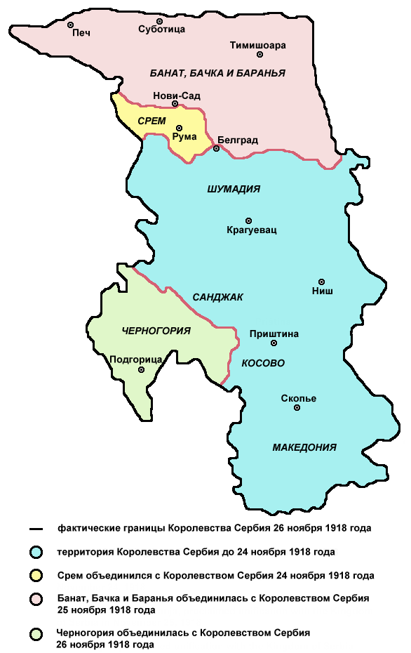
English: de facto borders of the Kingdom of Serbia in November 26, 1918, after unification with Syrmia (November 24), Banat, Bačka and Baranja (November 25) and Montenegro (November 26) - Russian language version
Српски / srpski: фактичке границе Краљевине Србије 26. новембра 1918. године, после уједињења са Сремом (24. новембра), Банатом, Бачком и Барањом (25. новембра) и Црном Гором (26. новембра) - верзија на руском језику
Русский: Карта Сербии 1918 год |
| Date | (UTC) |
| Source | Serbia1918.png |
| Author |
|
References edit
.png&action=edit§ion=2)
Published references:
- Drago Njegovan, Prisajedinjenje Vojvodine Srbiji, Novi Sad, 2004.
- Drago Njegovan, Prisajedinjenje Srema, Banata, Bačke i Baranje Srbiji 1918. - dokumenti i prilozi, Novi Sad, 2001.
- Lazo M. Kostić, Srpska Vojvodina i njene manjine, Novi Sad, 1999.
- Dimitrije Boarov, Politička istorija Vojvodine, Novi Sad, 2001.
- Dr Tomislav Bogavac, Nestajanje Srba, Niš, 1994.
- Čedomir Popov - Jelena Popov, Autonomija Vojvodine - srpsko pitanje, Sremski Karlovci, 2000.
- Rade Šumonja, Spomenica oslobođenja Sombora 1918-1998, Sombor, 1998.
Internet references:
Source and licence edit
.png&action=edit§ion=3)
| This is a retouched picture, which means that it has been digitally altered from its original version. Modifications: translated in Russian. The original can be viewed here: Serbia1918.png:
|

|
This map has been uploaded by Electionworld from en.wikipedia.org to enable the |
| This work has been released into the public domain by its author, PANONIAN. This applies worldwide. In some countries this may not be legally possible; if so: |
Original upload log edit
.png&action=edit§ion=4)
This image is a derivative work of the following images:
- File:Serbia1918.png licensed with PD-user
- 2007-08-31T21:13:30Z PANONIAN 586x936 (52747 Bytes)
- 2007-07-16T12:08:05Z Nihad Hamzic 640x826 (16182 Bytes) Greatly reduced image size by losslessly reducing color domain.
- 2007-07-08T19:13:10Z PANONIAN 640x826 (43182 Bytes)
- 2006-12-21T21:38:07Z Electionworld 665x1050 (104953 Bytes) {{ew|en|PANONIAN}} Self-made map by [[user:PANONIAN|PANONIAN]] {{PD-user|PANONIAN}} [[Category:Maps of Serbia]]
Uploaded with derivativeFX
File history
Click on a date/time to view the file as it appeared at that time.
| Date/Time | Thumbnail | Dimensions | User | Comment | |
|---|---|---|---|---|---|
| current | 20:08, 8 July 2009 | | 586 × 930 (63 KB) | PANONIAN (talk | contribs) | a small line correction |
| 19:16, 7 July 2009 |  | 586 × 930 (51 KB) | Tat1642 (talk | contribs) | update | |
| 12:06, 6 July 2009 |  | 580 × 900 (162 KB) | PANONIAN (talk | contribs) | ||
| 20:00, 4 June 2009 |  | 580 × 900 (143 KB) | Tat1642 (talk | contribs) | {{Information |Description= |Source=*File:Serbia1918.png |Date=2009-06-04 20:59 (UTC) |Author=*File:Serbia1918.png: Electionworld *derivative work: ~~~ |Permission=see below |other_versions= }} {{RetouchedPicture|transl |
You cannot overwrite this file.
File usage on Commons
There are no pages that use this file.
File usage on other wikis
The following other wikis use this file:
- Usage on ru.wikipedia.org
- Usage on uk.wikipedia.org
.png&oldid=601456967)