File:Spotters-hill-bunkers-ringvaart.jpg

Size of this preview: 794 × 599 pixels. Other resolutions: 318 × 240 pixels | 636 × 480 pixels | 1,018 × 768 pixels | 1,280 × 966 pixels | 1,632 × 1,232 pixels.
Original file (1,632 × 1,232 pixels, file size: 635 KB, MIME type: image/jpeg)
Captions
Captions
Add a one-line explanation of what this file represents
| Description |
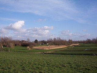
English: View from the Ringvaart dike of bunkers from Stelling van Amsterdam. In the distance is Big Spotters Hill, a manmade hill 42 meters high in the middle of the Haarlemmermeersebos park. This set of bunkers represented the first fore position of Fort Vijfhuizen. The spot is currently part of a golf course.
Nederlands: Gezicht vanaf de Ringdijk op bunkers horend bij Fort Vijfhuizen van de Stelling van Amsterdam. Op de achtergrond Big Spotters Hill, een heuvel aangelegd voor de Floriade in 2002. Op de voorgrond een golfbaan. |
| Date | |
| Source | Own work |
| Author | Jane023 |
| Permission (Reusing this file) |
PD |
| Camera location | | View this and other nearby images on: OpenStreetMap |
|---|
| I, the copyright holder of this work, release this work into the public domain. This applies worldwide. In some countries this may not be legally possible; if so: I grant anyone the right to use this work for any purpose, without any conditions, unless such conditions are required by law. |
File history
Click on a date/time to view the file as it appeared at that time.
| Date/Time | Thumbnail | Dimensions | User | Comment | |
|---|---|---|---|---|---|
| current | 19:45, 4 March 2007 | | 1,632 × 1,232 (635 KB) | Jane023 (talk | contribs) | View from the ringvaart dike of bunkers from Stelling van Amsterdam. In the distance is Spotter's Hill, a manmade hill 40 meters high in the middle of the Haarlemmermeersebos park. This set of bunkers represented the first fore position of Fort Vijfhuizen |
You cannot overwrite this file.
File usage on Commons
There are no pages that use this file.
File usage on other wikis
The following other wikis use this file:
- Usage on en.wikipedia.org
- Usage on hr.wikipedia.org
- Usage on it.wikipedia.org
- Usage on sr.wikipedia.org
- Usage on zh.wikipedia.org