File:Spuller See Panorama von Westen.jpg

Size of this preview: 799 × 265 pixels. Other resolutions: 320 × 106 pixels | 640 × 212 pixels | 1,024 × 340 pixels | 1,280 × 425 pixels | 2,560 × 849 pixels | 7,272 × 2,412 pixels.
Original file (7,272 × 2,412 pixels, file size: 14.78 MB, MIME type: image/jpeg)
Captions
Captions
Add a one-line explanation of what this file represents
| Description |
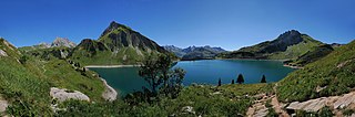
Deutsch: Der Spullersee ist ein Hochgebirgssee in Vorarlberg. Er wurde 1919 bis 1925 von den Österreichischen Bundesbahnen anlässlich der Elektrifizierung der Arlbergbahn errichtet und wird zur Energieerzeugung genutzt. Er liegt im Gemeindegebiet von Dalaas. Das Bergmassiv in der Bildmitte ist die Goppelspitze.
English: The Spullersee is a high mountain lake in Vorarlberg. It was built from 1919 to 1925 by the Austrian Federal Railways on the occasion of the Arlberg railway electrification and is used for energy. It is located in the municipality of Dalaas.
Français : Le Spullersee, un lac de barrage de haute montagne près de Dalaas, dans le Vorarlberg, en Autriche. Ce lac a été créé entre 1919 et 1925 par les chemins de fer fédéraux autrichiens pour électrifier la ligne de l'Arlberg.
|
||
| Date | |||
| Source | Own work | ||
| Author | böhringer friedrich | ||
| Permission (Reusing this file) |
I, the copyright holder of this work, hereby publish it under the following license: This file is licensed under the Creative Commons Attribution-Share Alike 2.5 Generic license.
|
||
| Other versions |


|
This Photo was taken by Böhringer Friedrich.
|
Feel free to use my photos, but please mention me as the author and if you want send me a message. or (rufre@lenz-nenning.at) |
| Camera location | | View this and other nearby images on: OpenStreetMap |
|---|
| Annotations | This image is annotated: View the annotations at Commons |
File history
Click on a date/time to view the file as it appeared at that time.
| Date/Time | Thumbnail | Dimensions | User | Comment | |
|---|---|---|---|---|---|
| current | 20:57, 31 August 2012 | 7,272 × 2,412 (14.78 MB) | Böhringer (talk | contribs) | {{Information |Description= {{de| Der '''Spullersee''' ist ein Hochgebirgssee in Vorarlberg. Er wurde 1919 bis 1925 von den Österreichischen Bundesbahnen anlässlich der Elektrifizierung der [[... |
You cannot overwrite this file.
File usage on Commons
The following 22 pages use this file:
- Exzellente Bilder aus Vorarlberg
- User:Böhringer
- User:Böhringer/Archive 5
- User:Ö/Best/2012
- Commons:Featured picture candidates/File:Spuller See Panorama von Westen.jpg
- Commons:Featured picture candidates/Log/September 2012
- Commons:Featured pictures/Places/Natural/Austria
- Commons:Featured pictures/Places/Panoramas
- Commons:Featured pictures/chronological/2012-B
- Commons:Photo challenge/2019 - February - Lakes
- Commons:Picture of the Year/2012/Galleries/2012-B
- Commons:Picture of the Year/2012/Galleries/ALL
- Commons:Picture of the Year/2012/Galleries/Index/12
- Commons:Picture of the Year/2012/Galleries/Panoramic views
- Commons:Picture of the Year/2012/Galleries/SEP
- Commons:Picture of the Year/2012/R1/Spuller See Panorama von Westen.jpg
- Commons:Picture of the Year/2012/Results/R1/ALL
- Commons:Picture of the Year/2012/Results/R1/ALL/gallery
- Commons:Picture of the Year/2012/Results/R1/ALL/thumbnailtable
- Commons:Picture of the Year/2012/Results/R1/Panoramic views
- Commons talk:Photo challenge/themes/Archive
- File:Goppelspitze and Spullersee.jpg
File usage on other wikis
The following other wikis use this file:
- Usage on de.wikipedia.org
- Usage on vi.wikipedia.org