File:Staré Ransko, most přes levé rameno Doubravy pod rybníkem Řeka.jpg
Size of this preview: 800 × 556 pixels. Other resolutions: 320 × 222 pixels | 640 × 445 pixels | 1,024 × 711 pixels | 1,280 × 889 pixels | 2,508 × 1,742 pixels.
Original file (2,508 × 1,742 pixels, file size: 1.18 MB, MIME type: image/jpeg)
File information
Structured data
Captions
Summary
editDescriptionStaré Ransko, most přes levé rameno Doubravy pod rybníkem Řeka.jpg |
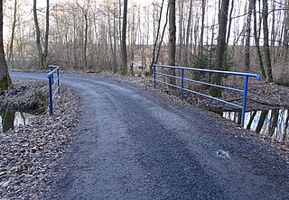
Čeština: Krucemburk-Staré Ransko, okres Havlíčkův Brod. Most přes levé rameno Doubravy pod rybníkem Řeka.
English: Krucemburk-Staré Ransko, Havlíčkův Brod District, Vysočina Region, Czechia. A bridge over the left arm of the Doubrava below Řeka pond.
|
||||
Date | Taken on 27 February 2022 | ||||
Source | Self-photographed | ||||
Author | ŠJů | ||||
Permission (Reusing this file) |
I, the copyright holder of this work, hereby publish it under the following license: This file is licensed under the Creative Commons Attribution 4.0 International license. Attribution: ŠJů, Wikimedia Commons
|
File history
Click on a date/time to view the file as it appeared at that time.
Date/Time | Thumbnail | Dimensions | User | Comment | |
---|---|---|---|---|---|
current | 00:59, 6 August 2024 | 2,508 × 1,742 (1.18 MB) | ŠJů (talk | contribs) | {{Information |Description= {{cs|1=cs:Krucemburk-cs:Staré Ransko, okres Havlíčkův Brod. Most přes levé rameno Doubravy pod rybníkem Řeka.}} {{en|1=en:Krucemburk-Staré Ransko, Havlíčkův Brod District, Vysočina Region, Czechia. A bridge over the left arm of the Doubrava below Řeka pond.}} {{location|49.6765383|15.8407650|region:CZ_heading:080}} |Date= {{Taken on|2022-02-27}} |... |
You cannot overwrite this file.
File usage on Commons
There are no pages that use this file.
Metadata
This file contains additional information such as Exif metadata which may have been added by the digital camera, scanner, or software program used to create or digitize it. If the file has been modified from its original state, some details such as the timestamp may not fully reflect those of the original file. The timestamp is only as accurate as the clock in the camera, and it may be completely wrong.
Camera manufacturer | SONY |
---|---|
Camera model | DSC-HX400V |
Exposure time | 1/100 sec (0.01) |
F-number | f/3.2 |
ISO speed rating | 250 |
Date and time of data generation | 15:39, 27 February 2022 |
Lens focal length | 4.97 mm |
Latitude | 49° 40′ 35.62″ N |
Longitude | 15° 50′ 26.6″ E |
Altitude | 554 meters above sea level |
Orientation | Normal |
Horizontal resolution | 350 dpi |
Vertical resolution | 350 dpi |
Software used | DSC-HX400V v2.10 |
File change date and time | 15:39, 27 February 2022 |
Y and C positioning | Co-sited |
Exposure Program | Normal program |
Exif version | 2.3 |
Date and time of digitizing | 15:39, 27 February 2022 |
Meaning of each component |
|
Image compression mode | 6 |
APEX brightness | 5.13046875 |
APEX exposure bias | 0 |
Maximum land aperture | 2.96875 APEX (f/2.8) |
Metering mode | Pattern |
Light source | Unknown |
Flash | Flash did not fire, compulsory flash suppression |
Supported Flashpix version | 1 |
Color space | sRGB |
File source | Digital still camera |
Scene type | A directly photographed image |
Custom image processing | Normal process |
Exposure mode | Auto exposure |
White balance | Auto white balance |
Digital zoom ratio | 1 |
Scene capture type | Standard |
Contrast | Normal |
Saturation | Normal |
Sharpness | Normal |
GPS time (atomic clock) | 14:39 |
Receiver status | Measurement in progress |
Measurement mode | 3-dimensional measurement |
Measurement precision | Poor (1.47) |
Speed unit | Kilometers per hour |
Speed of GPS receiver | 3.36 |
Reference for direction of movement | True direction |
Direction of movement | 87.69 |
Geodetic survey data used | WGS-84 |
GPS date | 27 February 2022 |
GPS differential correction | 0 |
GPS tag version | 0.0.3.2 |