File:Stobberbach 04.jpg

Size of this preview: 443 × 599 pixels. Other resolutions: 177 × 240 pixels | 355 × 480 pixels | 568 × 768 pixels | 757 × 1,024 pixels | 1,514 × 2,048 pixels | 2,571 × 3,478 pixels.
Original file (2,571 × 3,478 pixels, file size: 3.07 MB, MIME type: image/jpeg)
Captions
Captions
Add a one-line explanation of what this file represents
Summary edit
| Description |
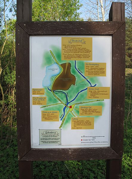
Deutsch: Informationsschild/Karte von Liebenberg, einem Teil von Kienbaum, Ortsteil der Gemeinde Grünheide. Das Schild steht an der Brücke über die Löcknitz und bezeichnet den Stobberbach mit seinem historischen Namen Köpernitz. Der Stobberbach (oder Stöbberbach, Köpernitz) ist ein Bach in der Brandenburger Märkischen Schweiz. Der 6 Kilometer lange Bach fließt vom Quell- und Niedermoorgebiet Rotes Luch nach Südwesten zum Grünheider Ortsteil Kienbaum, wo er sich mit dem aus dem Maxsee kommenden Mühlenfließ zur Löcknitz vereinigt. Die Löcknitz entwässert über die Spree, Havel und Elbe in die Nordsee. Laut Inschrift wurde die Karte aus historischen Quellen recherchiert und zusammengestellt von E. Flucke, Kienbaum. Das Grafikdesign besorgte Jan Schütze, http://DracoBlue.com.
English: Information board/map in Liebenberg, a part of Kienbaum, district of the municipality Grünheide. The board is situated on the bridge over the river Löcknitz and referres the Stobberbach with its historical name Köpernitz. The Stobberbach (also called Stöbberbach or Köpernitz) is a river in the hill country „Märkische Schweiz“, Brandenburg, Germany. The stream runs over a distance of 6 kilometers from the lowland moor and source area Rotes Luch towards the southwest to the district Kienbaum of the municipality Grünheide. Here it merges with the Mühlenfließ (coming from the Maxsee) to the river Löcknitz (Spree), whose waters run over the rivers Spree, Havel and Elbe to the North Sea. According to the inscription the map was created by historical sources from E. Flucke, Kienbaum. The graphic design did Jan Schütze, http://DracoBlue.com. |
| Date | |
| Source | Own work |
| Author | Lienhard Schulz |
| Permission (Reusing this file) |
Painting is gemeinfrei (~ Public Domain) because of Panoramafreiheit |
Licensing edit
I, the copyright holder of this work, hereby publish it under the following licenses:

|
Permission is granted to copy, distribute and/or modify this document under the terms of the GNU Free Documentation License, Version 1.2 or any later version published by the Free Software Foundation; with no Invariant Sections, no Front-Cover Texts, and no Back-Cover Texts. A copy of the license is included in the section entitled GNU Free Documentation License. |
This file is licensed under the Creative Commons Attribution-Share Alike 3.0 Unported license.
- You are free:
- to share – to copy, distribute and transmit the work
- to remix – to adapt the work
- Under the following conditions:
- attribution – You must give appropriate credit, provide a link to the license, and indicate if changes were made. You may do so in any reasonable manner, but not in any way that suggests the licensor endorses you or your use.
- share alike – If you remix, transform, or build upon the material, you must distribute your contributions under the same or compatible license as the original.
You may select the license of your choice.
File history
Click on a date/time to view the file as it appeared at that time.
| Date/Time | Thumbnail | Dimensions | User | Comment | |
|---|---|---|---|---|---|
| current | 08:26, 17 May 2012 | | 2,571 × 3,478 (3.07 MB) | Lienhard Schulz (talk | contribs) | {{Information |Description= {{de|Informationsschild/Karte von Liebenberg, einem Teil von Kienbaum, Ortsteil der Gemeinde Grünheide. Das Schild steht an der Brücke über die Löcknitz und bezeichnet ... |
You cannot overwrite this file.
File usage on Commons
There are no pages that use this file.
File usage on other wikis
The following other wikis use this file:
- Usage on de.wikipedia.org