File:Superficie por zonas altimétricas 2.png
No higher resolution available.
Superficie_por_zonas_altimétricas_2.png (796 × 502 pixels, file size: 33 KB, MIME type: image/png)
Captions
Captions
Add a one-line explanation of what this file represents
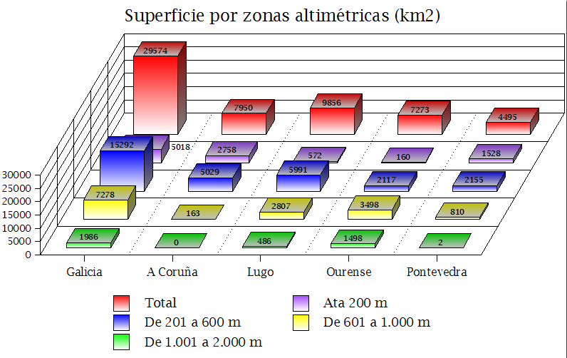
| Description | Superficie por zonas altimétricas (IGE) |
| Date | 30 - novembro (11) -2007 |
| Source | Own work |
| Author | Lmbuga |
| Permission (Reusing this file) |
Dominio Público |
| I, the copyright holder of this work, release this work into the public domain. This applies worldwide. In some countries this may not be legally possible; if so: I grant anyone the right to use this work for any purpose, without any conditions, unless such conditions are required by law. |
File history
Click on a date/time to view the file as it appeared at that time.
| Date/Time | Thumbnail | Dimensions | User | Comment | |
|---|---|---|---|---|---|
| current | 16:09, 30 November 2007 | | 796 × 502 (33 KB) | Lmbuga (talk | contribs) | {{Information |Description= Superficie por zonas altimétricas (IGE) |Source=self-made |Date=30 - novembro (11) -2007 |Author= Lmbuga |Permission=Dominio Público |other_versions= }} {{PD-self}} |
You cannot overwrite this file.
File usage on Commons
The following page uses this file:
File usage on other wikis
The following other wikis use this file:
- Usage on gl.wikipedia.org