File:Swisstopo Skiroutenkarte Montana LT LK 273 S 1955.jpg

Size of this preview: 800 × 583 pixels. Other resolutions: 320 × 233 pixels | 640 × 466 pixels | 1,024 × 746 pixels | 1,280 × 933 pixels | 2,560 × 1,865 pixels | 15,544 × 11,325 pixels.
Original file (15,544 × 11,325 pixels, file size: 163.81 MB, MIME type: image/jpeg)
Captions
Captions
Add a one-line explanation of what this file represents
Summary edit
| Warning | The original file is very high-resolution. It might not load properly or could cause your browser to freeze when opened at full size. |
|---|
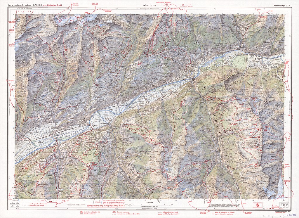
| Title |
Skiroutenkarte Montana, LT LK 273 S 1955 |
|||||||||||||||||||||||||
| Map legend |
Français : Signes conventionnels, Ecritures (1950) |
|||||||||||||||||||||||||
| Adjacent sheets |
|
|||||||||||||||||||||||||
| Source | https://www.swisstopohistoric.ch/text-und-ton/blog/leidgenoessischer-widerstandr-und-die-ersten-skiroutenkarten-151.html | |||||||||||||||||||||||||
| Creator | ||||||||||||||||||||||||||
| Geotemporal data | ||||||||||||||||||||||||||
| Date depicted | ||||||||||||||||||||||||||
| Spatial reference system | projection autogonale cylindrique à axe oblique | |||||||||||||||||||||||||
| Scale | 1:50,000 | |||||||||||||||||||||||||
| Heading |
 |
|||||||||||||||||||||||||
| Georeferencing | If inappropriate please set warp_status = skip to hide. | |||||||||||||||||||||||||
| Bibliographic data | ||||||||||||||||||||||||||
| Part of the series | Skiroutenkarten | |||||||||||||||||||||||||
| Map sheet | 273 S | |||||||||||||||||||||||||
| Language | French | |||||||||||||||||||||||||
| Publisher |
Service topographique fédéral, Wabern-Berne |
|||||||||||||||||||||||||
| Archival data | ||||||||||||||||||||||||||
| Collection |
|
|||||||||||||||||||||||||
| Accession number |
LT LK 273 S 1955 |
|||||||||||||||||||||||||
| Other versions |
|
|||||||||||||||||||||||||

Licensing edit
The data made publicly available by swisstopo may be used, distributed and made accessible. Furthermore, they may be enriched and processed and also used commercially. A reference to the source is mandatory. In the case of digital or analogue representations and publications, as well as in the case of dissemination, one of the following source references must be attached in any case:
Terms of use for free geodata and geoservices (OGD) from swisstopo
|
.svg) |
File history
Click on a date/time to view the file as it appeared at that time.
| Date/Time | Thumbnail | Dimensions | User | Comment | |
|---|---|---|---|---|---|
| current | 14:03, 5 October 2023 | | 15,544 × 11,325 (163.81 MB) | Yann (talk | contribs) | c:User:Rillke/bigChunkedUpload.js: |
You cannot overwrite this file.
File usage on Commons
The following page uses this file: