File:Tøyen Områdeløft Kart.jpg
Size of this preview: 800 × 356 pixels. Other resolutions: 320 × 142 pixels | 940 × 418 pixels.
Original file (940 × 418 pixels, file size: 178 KB, MIME type: image/jpeg)
Captions
Captions
Add a one-line explanation of what this file represents
Summary
edit
| Description |
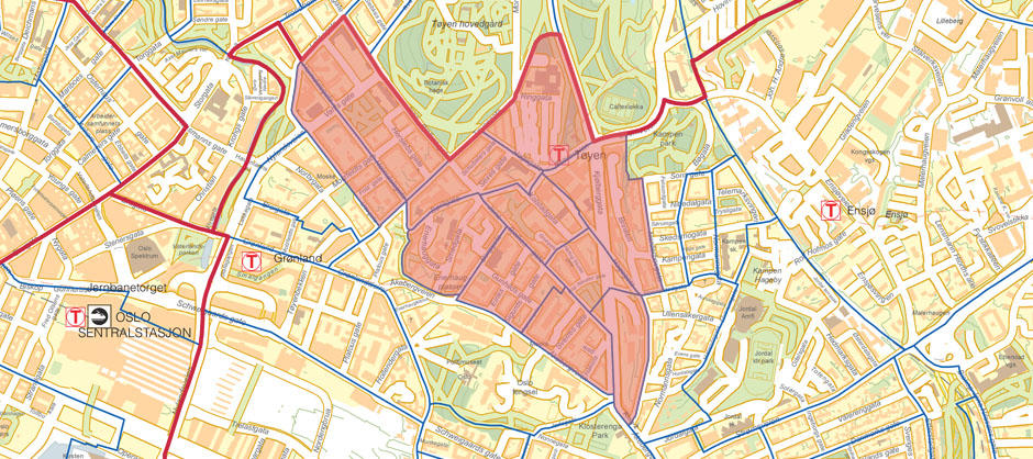
Norsk bokmål: Kart over de bebygde delene av Tøyen beliggende i Bydel Gamle Oslo. |
| Date | |
| Source | Oslo Kommune - Tøyensatsingen (Områdeprogram) |
| Author | Områdeløft Tøyen er et områdeprogram over fem år som skal bedre levekårene til folk på Tøyen. |
Licensing
edit
| This file is in the public domain because legal statutes, administrative regulations, court decisions and other decisions by public authorities are unprotected. This is also the case with proposals, reports and other statements which concern the public exercise of authority, and which are made by a public authority, a publicly appointed council or committee, or published by the public authorities. Similarly, official translations of such texts are unprotected. Intellectual works ("åndsverk" as defined in § 2) which have not been produced specially for use in documents specified in the first paragraph, and from which parts are quoted or which are reproduced in a separate appendix, are not covered by this provision. The same apply to poetry, musical compositions or works of art.
|
 |
File history
Click on a date/time to view the file as it appeared at that time.
| Date/Time | Thumbnail | Dimensions | User | Comment | |
|---|---|---|---|---|---|
| current | 12:31, 19 July 2015 | | 940 × 418 (178 KB) | Yosh3000 (talk | contribs) | User created page with UploadWizard |
You cannot overwrite this file.
File usage on Commons
There are no pages that use this file.
File usage on other wikis
The following other wikis use this file:
- Usage on no.wikipedia.org