File:Těšínský kraj 1844.svg

Size of this PNG preview of this SVG file: 800 × 432 pixels. Other resolutions: 320 × 173 pixels | 640 × 346 pixels | 1,024 × 554 pixels | 1,280 × 692 pixels | 2,560 × 1,384 pixels | 1,850 × 1,000 pixels.
Original file (SVG file, nominally 1,850 × 1,000 pixels, file size: 249 KB)
Captions
Captions
Add a one-line explanation of what this file represents
| Description |
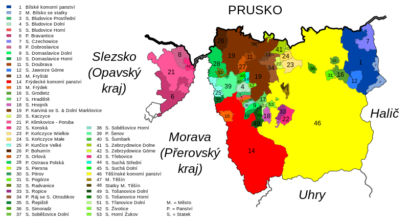
Čeština: Těšínský kraj roku 1844
Deutsch: Teschner Kreis, 1844 |
|||
| Date | ||||
| Source | based on Conrad Schenkl: Die Markgrafschaft Mähren mit dem Herzogthume Schlesien in acht, die einzelnen Kreise darstellenden Blättern, nach den neuesten astronomischen und geometrischen Messungen. Als Land-, Wasser-, Strassen-, Eisenbahn, Post- und Herrschafts-Gränzkarte | |||
| Author | Daniel Baránek | |||
| Permission (Reusing this file) |
This file is licensed under the Creative Commons Attribution-Share Alike 3.0 Unported license. Attribution: Daniel Baránek
|

File history
Click on a date/time to view the file as it appeared at that time.
| Date/Time | Thumbnail | Dimensions | User | Comment | |
|---|---|---|---|---|---|
| current | 11:10, 14 September 2008 | | 1,850 × 1,000 (249 KB) | Daniel Baránek (talk | contribs) | {{Information |Description= {{cs|Těšínský kraj roku 1844}} {{de|Teschner Kreis, 1844}} |Source=based on [http://www.vkol.cz/mapy/v51871_007.htm Conrad Schenkl: Die Markgrafschaft Mähren mit dem Herzogt |
You cannot overwrite this file.
File usage on Commons
The following page uses this file:
File usage on other wikis
The following other wikis use this file:
- Usage on cs.wikipedia.org
- Usage on eo.wikipedia.org