File:Taklimakanm.jpg

Size of this preview: 800 × 600 pixels. Other resolutions: 320 × 240 pixels | 640 × 480 pixels | 1,024 × 768 pixels | 1,280 × 960 pixels | 2,560 × 1,920 pixels | 4,800 × 3,600 pixels.
Original file (4,800 × 3,600 pixels, file size: 2.79 MB, MIME type: image/jpeg)
Captions
Captions
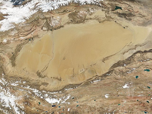
Satellite photo of the Taklamakan desert
Summary
edit
| Description |
English: The Taklamakan Desert in northwest China is a vast region of sand desert sitting in a depression between two high, rugged mountain ranges. Seen in this true-color MODIS image from October 27, 2001, the Taklimakan's rolling sand dunes stretch out over several hundred thousand square miles in the Xinjiang region of China. The desert is hemmed in to the north by the snow-covered Tien Shan Mountain range and to the south by the rugged Kunlun Mountains. At the lower left corner of the image is the Karakoram Mountain range, where the world's second highest mountain, K2, casts a blue shadow (see high-resolution image for an up-close look). Desertification and shifting sand dunes are a major concern for the farmers and herders who live at the Taklimakan's edge. At the bottom of the image lies the Tibetan Plateau. |
| Date | Taken on 27 October 2001 |
| Source | http://www.gsfc.nasa.gov/indepth/photos_earth2001_p1.html (archive) |
| Author | NASA/GSFC/MODIS Team |
Licensing
edit
| This file is in the public domain in the United States because it was solely created by NASA. NASA copyright policy states that "NASA material is not protected by copyright unless noted". (See Template:PD-USGov, NASA copyright policy page or JPL Image Use Policy.) | ||
 |
Warnings:
|
File history
Click on a date/time to view the file as it appeared at that time.
| Date/Time | Thumbnail | Dimensions | User | Comment | |
|---|---|---|---|---|---|
| current | 02:05, 27 September 2020 | | 4,800 × 3,600 (2.79 MB) | Huntster (talk | contribs) | 250m resolution version. |
| 21:33, 23 August 2005 |  | 1,200 × 900 (324 KB) | Nanosmile (talk | contribs) | Description: The Taklimakan Desert in northwest China is a vast region of sand desert sitting in a depression between two high, rugged mountain ranges. Seen in this true-color MODIS image from October 27, 2001, the Taklimakan's rolling sand dunes stretch |
You cannot overwrite this file.
File usage on Commons
The following 2 pages use this file:
File usage on other wikis
The following other wikis use this file:
- Usage on af.wikipedia.org
- Usage on als.wikipedia.org
- Usage on bn.wikipedia.org
- Usage on br.wikipedia.org
- Usage on ca.wikipedia.org
- Usage on de.wikipedia.org
- Usage on en.wikipedia.org
- Usage on eo.wikipedia.org
- Usage on es.wikipedia.org
- Usage on et.wikipedia.org
- Usage on eu.wikipedia.org
- Usage on fa.wikipedia.org
- Usage on fi.wikipedia.org
- Usage on fr.wikipedia.org
- Usage on gl.wikipedia.org
- Usage on he.wikipedia.org
- Usage on hu.wikipedia.org
- Usage on hy.wikipedia.org
- Usage on id.wikipedia.org
- Usage on it.wikipedia.org
- Usage on ku.wikipedia.org
- Usage on ky.wikipedia.org
- Usage on nds.wikipedia.org
- Usage on nn.wikipedia.org
- Usage on no.wikipedia.org
- Usage on pt.wikipedia.org
- Usage on ro.wikipedia.org
- Usage on ru.wikipedia.org
- Usage on sr.wikipedia.org
- Usage on th.wikipedia.org
View more global usage of this file.