File:Tamis banat1718 1739.png

Size of this preview: 465 × 599 pixels. Other resolutions: 186 × 240 pixels | 373 × 480 pixels | 1,008 × 1,298 pixels.
Original file (1,008 × 1,298 pixels, file size: 146 KB, MIME type: image/png)
Captions
Captions
Add a one-line explanation of what this file represents
Summary
edit
| Description |
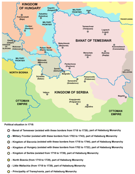
English: Map of the Banat of Temeswar, Kingdom of Serbia and Military Frontier in 1718. Serbian: Мапа Тамишког Баната, Краљевине Србије и војне границе 1718. године. |
| Date | |
| Source | Own work |
| Author | PANONIAN |
Licensing
edit
| I, the copyright holder of this work, release this work into the public domain. This applies worldwide. In some countries this may not be legally possible; if so: I grant anyone the right to use this work for any purpose, without any conditions, unless such conditions are required by law. |
References
edit
- The Times History of Europe, Times Books, London, 2002.
- Istorijski atlas, Zavod za udžbenike i nastavna sredstva - Zavod za kartografiju "Geokarta", Beograd, 1999.
- Školski istorijski atlas, Zavod za izdavanje udžbenika Socijalističke Republike Srbije, Beograd, 1970.
- Denis Šehić - Demir Šehić, Istorijski atlas Sveta, Beograd, 2007.
- Milan Tutorov, Banatska rapsodija - istorika Zrenjanina i Banata, Novi Sad, 2001.
- Peter Rokai - Zoltan Đere - Tibor Pal - Aleksandar Kasaš, Istorija Mađara, Beograd, 2002.
- Dr Dušan J. Popović, Srbi u Vojvodini, knjiga 2, Novi Sad, 1990.
- Dr Milenko Palić, Srbi u Mađarskoj - Ugarskoj do 1918, Novi Sad, 1995.
- J. H. Šviker, Politička istorija Srba u Ugarskoj, Novi Sad - Beograd, 1998.
- Fridrih Vilhelm fon Taube, Istorijski i geografski opis Kraljevine Slavonije i Vojvodstva Srema, Novi Sad, 1998.
- Miodrag Milin, Vekovima zajedno (Iz istorije srpsko-rumunskih odnosa), Temišvar, 1995.
- Suzana Milovanović, Potiska i pomoriška vojna granica (1702-1751), Novi Sad, 2003.
- Dimitrije Boarov, Politička istorija Vojvodine, Novi Sad, 2001.
- Drago Njegovan, Prisajedinjenje Vojvodine Srbiji, Novi Sad, 2004.
- Olga Zirojević, Srbija pod turskom vlašću 1459-1804, Beograd, 2007.
- Vladimir Ćorović, Ilustrovana istorija Srba, knjiga četvrta, Beograd, 2006.
- http://www.conflicts.rem33.com/images/Ungarn/OESTEREICH%20ENTWICKLUNG.jpg
- http://terkepek.adatbank.transindex.ro/kepek/netre/51.gif
- http://upload.wikimedia.org/wikipedia/commons/8/8e/Growth_of_Habsburg_territories.jpg
- http://images.nationmaster.com/images/motw/historical/ward_1912/south_east_europe_1648.jpg archive copy at the Wayback Machine
- http://dic.academic.ru/pictures/dewiki/80/Passarowitz_1718.JPG
- http://upload.wikimedia.org/wikipedia/commons/7/7c/Temeswarer_Banat.JPG
- http://gettysburg.cdmhost.com/cdm4/item_viewer.php?CISOROOT=/p4016coll7&CISOPTR=429&CISOBOX=1&REC=2
- http://www.garwood-voigt.com/catalogues/H22365SclavoniaeHomann.jpg
File history
Click on a date/time to view the file as it appeared at that time.
| Date/Time | Thumbnail | Dimensions | User | Comment | |
|---|---|---|---|---|---|
| current | 22:47, 23 June 2014 | | 1,008 × 1,298 (146 KB) | PANONIAN (talk | contribs) | aesthetics |
| 11:07, 23 June 2014 |  | 1,008 × 1,298 (146 KB) | PANONIAN (talk | contribs) | aesthetics | |
| 09:12, 12 September 2013 |  | 1,008 × 1,298 (149 KB) | PANONIAN (talk | contribs) | correction | |
| 18:34, 13 February 2013 |  | 1,008 × 1,298 (149 KB) | PANONIAN (talk | contribs) | correction | |
| 13:15, 22 December 2012 |  | 1,008 × 1,298 (149 KB) | PANONIAN (talk | contribs) | minor aesthetical improvement | |
| 17:07, 30 September 2011 |  | 998 × 1,294 (149 KB) | PANONIAN (talk | contribs) | correction | |
| 15:47, 29 September 2011 |  | 998 × 1,294 (149 KB) | PANONIAN (talk | contribs) | correction | |
| 14:07, 29 September 2011 |  | 998 × 1,294 (149 KB) | PANONIAN (talk | contribs) | some corrections and improvements | |
| 19:52, 21 December 2009 |  | 998 × 1,206 (144 KB) | PANONIAN (talk | contribs) | {{Information |Description={{en|1=Map of the Banat of Temeswar and Military Frontier in 1718}} |Source={{own}} |Author=PANONIAN |Date= |Permission= |other_versions= }} |
You cannot overwrite this file.
File usage on Commons
The following 4 pages use this file:
File usage on other wikis
The following other wikis use this file:
- Usage on ar.wikipedia.org
- Usage on az.wikipedia.org
- Usage on be-tarask.wikipedia.org
- Usage on be.wikipedia.org
- Usage on bg.wikipedia.org
- Usage on bs.wikipedia.org
- Usage on ca.wikipedia.org
- Usage on cs.wikipedia.org
- Usage on da.wikipedia.org
- Usage on de.wikipedia.org
- Usage on el.wikipedia.org
- Usage on en.wikipedia.org
- Usage on es.wikipedia.org
- Usage on eu.wikipedia.org
- Usage on fa.wikipedia.org
- Usage on fr.wikipedia.org
- Usage on gl.wikipedia.org
- Usage on he.wikipedia.org
- Usage on hr.wikipedia.org
- Usage on it.wikipedia.org
- Usage on ko.wikipedia.org
- Usage on mk.wikipedia.org
- Usage on mr.wikipedia.org
- Usage on nl.wikipedia.org
View more global usage of this file.