File:TchoutacabouffaRiver1998.jpg

Size of this preview: 800 × 541 pixels. Other resolutions: 320 × 217 pixels | 640 × 433 pixels | 875 × 592 pixels.
Original file (875 × 592 pixels, file size: 152 KB, MIME type: image/jpeg)
Captions
Captions
Add a one-line explanation of what this file represents
Summary
edit
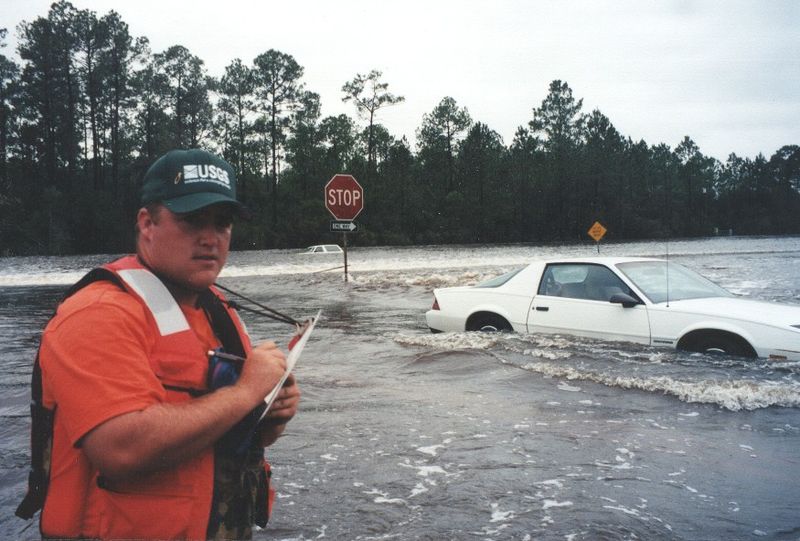
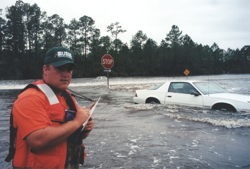
| Description | D'Iberville, Mississippi. Water flowing over Mississippi Highway 67 and Mississippi Highway 15 near their intersection during the September 1998 flooding caused on the Tchoutacabouffa River by Hurricane Georges. |
| Date | |
| Source | USGS Surface Water Photo Gallery: item 17 11 |
| Author | Trent Baldwin (submitted by Van Wilson, Mississippi) |
| Permission (Reusing this file) |
Public Domain |
| Camera location | | View this and other nearby images on: OpenStreetMap |
|---|
Licensing
edit
This image is in the public domain in the United States because it only contains materials that originally came from the United States Geological Survey, an agency of the United States Department of the Interior. For more information, see the official USGS copyright policy.
|
Wikipedia upload log
edit
A Wikipedia description page is/was here. All following user names refer to en.wikipedia.
- 22:28, September 3, 2008 Suntag (34 bytes)
File history
Click on a date/time to view the file as it appeared at that time.
| Date/Time | Thumbnail | Dimensions | User | Comment | |
|---|---|---|---|---|---|
| current | 18:52, 9 February 2011 | | 875 × 592 (152 KB) | Infrogmation (talk | contribs) | == Summary == {{Information |Description= D'Iberville, Mississippi. Water flowing over Old Hwy 67 and MS 15 near their intersection on September 29, 1998 during the September 1998 flooding caused on th |
You cannot overwrite this file.
File usage on Commons
The following 2 pages use this file:
File usage on other wikis
The following other wikis use this file:
- Usage on ar.wikipedia.org
- Usage on arz.wikipedia.org
- Usage on ca.wikipedia.org
- Usage on ceb.wikipedia.org
- Usage on ce.wikipedia.org
- Usage on cy.wikipedia.org
- Usage on en.wikipedia.org
- Usage on en.wikivoyage.org
- Usage on eu.wikipedia.org
- Usage on ht.wikipedia.org
- Usage on it.wikipedia.org
- Usage on lld.wikipedia.org
- Usage on pl.wikipedia.org
- Usage on pt.wikipedia.org
- Usage on tt.wikipedia.org
- Usage on uz.wikipedia.org
- Usage on vi.wikipedia.org
- Usage on www.wikidata.org
- Usage on zh-min-nan.wikipedia.org