File:Temples, Nubia - Island of Philae - UNESCO - PHOTO0000003350 0000.tiff

Size of this JPG preview of this TIF file: 800 × 594 pixels. Other resolutions: 320 × 238 pixels | 640 × 475 pixels | 1,024 × 760 pixels | 1,280 × 951 pixels | 2,560 × 1,901 pixels | 5,742 × 4,264 pixels.
Original file (5,742 × 4,264 pixels, file size: 70.39 MB, MIME type: image/tiff)
Captions
Captions
Add a one-line explanation of what this file represents
Summary edit
| Photographer |
|
||||||||||||||||
| Description |
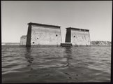
Français : Le temple est submmergé par les eaux du Nil. On ne voit plus que deux façades gravées de figures immenses. On devine le haut de l'entrée. Une autre façade également gravée apparait derrière. |
||||||||||||||||
| Depicted place | Nubian Monuments from Abu Simbel to Philae (Q4923872), Egypt (Q79) | ||||||||||||||||
| Keywords | Temples, Egyptology, Cultural landscapes, Preservation of monuments, | ||||||||||||||||
| Date | September 1968 | ||||||||||||||||
| Accession number |
PHOTO0000003350 |
||||||||||||||||
| Inscriptions |
English: The International Campaign for the saving of the Nubian monuments was launched by UNESCO in 1960. Famed for its monuments, the island of Philae in the River Nile has been submerged nine months out of twelve since the first Aswan dam. The construction of the High Dam above the island has worsened the situation; not only are the monuments permanently flooded to a third of their height, but they are subject to daily fluctuations in the water level which eat away their foundations and threaten to bring them down to ruins. In May 1968. the Campaign's Executive Committee endorsed the decision taken by the U.A.R. to dismantle and re-erect the monuments on the neighbouring island of Agilkia which is sufficiently elevated to be above the maximum level of the water. Here, the Temple of Isis. Français : Campagne internationale pour la sauvegarde des monuments de Nubie lancée par l'UNESCO en 1960. Célèbre pour ses monuments, l'ile de Philae était submergée neuf mois sur douze despuis la construction du premier barrage d'Assouan. La cons-truction du Haut Barrage, en amont del'ile, ne devait qu'aggraver la situation; les monuments plongent en permanence dans l'eau sur un tiers environ de leurhauteur et ils sont soumis à des variations quotidiennes de nivesu qui ont pour effet d'user les fondements et d'entrainer iné-vitablement l'effondrement de l'esemble. En Mai 1968, le Comité exécutif de la Campagne s'est dono associé à la décision prise par la R.A.U. pour déplacer et reconstruire les monuments sur l'ile voisine d'Agilkia, asses élevée pour toujours émerger au-dessus du niveau maximum des eaux. Ioi, le Temple d'Isis. |
||||||||||||||||
| Archival code | 35.002 | ||||||||||||||||
| Source |
|
||||||||||||||||
| Permission (Reusing this file) |
This file is licensed under the Creative Commons Attribution-ShareAlike 3.0 IGO license. Attribution: UNESCO / Dominique Roger
|
||||||||||||||||
| Other versions |
|
||||||||||||||||

File history
Click on a date/time to view the file as it appeared at that time.
| Date/Time | Thumbnail | Dimensions | User | Comment | |
|---|---|---|---|---|---|
| current | 10:55, 6 November 2020 |  | 5,742 × 4,264 (70.39 MB) | AliciaFagervingWMSE-bot (talk | contribs) | pattypan 20.04 |
You cannot overwrite this file.
File usage on Commons
The following 3 pages use this file: