File:The Maumee River Entering Maumee Bay in Lake Erie, Toledo, Ohio (7238185804).jpg

Original file (4,000 × 3,000 pixels, file size: 2.18 MB, MIME type: image/jpeg)
Captions
Captions
Summary
edit.jpg&action=edit§ion=1)
| Description |
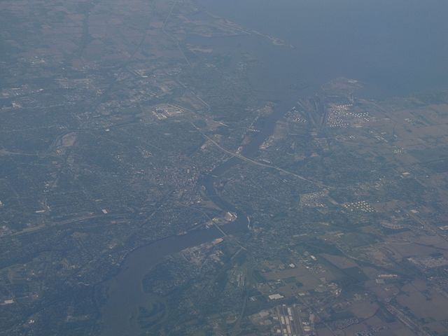
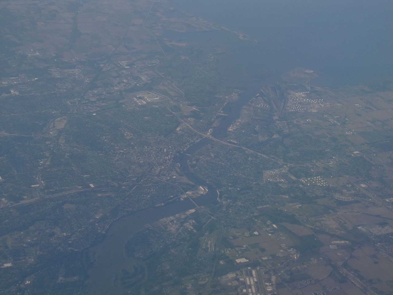
The Maumee River is a river in northwestern Ohio and northeastern Indiana in the United States. It is formed at Fort Wayne, Indiana by the confluence of the St. Joseph and St. Marys rivers, and meanders northeastwardly for 137 miles (220 km) through an agricultural region of glacial moraines before flowing into the Maumee Bay of Lake Erie at the city of Toledo, Ohio. It was designated an Ohio State Scenic River on July 18, 1974. Historically the river was also known as the "Miami" in United States treaties with Native Americans. As early as 1671, French colonists called the river was called Miami du Lac, or Miami of the Lake (in contrast to the "Miami of the Ohio" or the Great Miami River). Maumee is an anglicized spelling of the Ottawa name for the Miami Indians, Maamii. The Battle of Fallen Timbers, the final battle of the Northwest Indian War, was fought 3/4 mile (1.2 km) north of the banks of the Maumee River. After this decisive victory for General Anthony Wayne, Native Americans ceded a twelve mile square tract around Perrysburg and Maumee to the United States by the Treaty of Greenville in 1795. Lands north of the river and downstream of Defiance were ceded in 1807, and the rest of the Maumee River valley was ceded in 1817. The mouth of the river at Lake Erie is wide and supports considerable commercial traffic, including oil, grain, and coal. However, about 12 miles (19 km) upstream, in the town of Perrysburg, Ohio, the river becomes much shallower and supports only recreational navigation above that point. The abandoned Miami and Erie Canal paralleled the Maumee between Defiance, Ohio and Toledo; portions of its towpath are currently maintained for recreational use. The Wabash and Erie Canal continued on from Defiance to Fort Wayne, crossing the "summit" to the Wabash River valley. Both were important pre-railway transportation methods in the 1840-60 period. The Miami and Erie was north of the river, until it crossed an aqueduct and turned south at Defiance, headed for Cincinnati. The Wabash canal was south of the Maumee until it reached Fort Wayne. The Maumee has the largest watershed of any Great Lakes river with 8,316 square miles (21,540 km2). Its watershed includes a portion of southern Michigan. In addition to its source tributaries the St. Joseph and St. Marys rivers, the Maumee's principal tributaries are the Auglaize River and the Tiffin River, which join it at Defiance from the south and north, respectively. en.wikipedia.org/wiki/Maumee_River en.wikipedia.org/wiki/Wikipedia:Text_of_Creative_Commons_... |
| Date | |
| Source | The Maumee River Entering Maumee Bay in Lake Erie, Toledo, Ohio |
| Author | Ken Lund from Reno, Nevada, USA |
| Camera location | | View this and other nearby images on: OpenStreetMap |
|---|
.jpg¶ms=041.651014_N_-083.528848_E_globe:Earth_type:camera_source:Flickr_&language=en)
Licensing
edit.jpg&action=edit§ion=2)
- You are free:
- to share – to copy, distribute and transmit the work
- to remix – to adapt the work
- Under the following conditions:
- attribution – You must give appropriate credit, provide a link to the license, and indicate if changes were made. You may do so in any reasonable manner, but not in any way that suggests the licensor endorses you or your use.
- share alike – If you remix, transform, or build upon the material, you must distribute your contributions under the same or compatible license as the original.
| This image was originally posted to Flickr by Ken Lund at https://flickr.com/photos/75683070@N00/7238185804. It was reviewed on 3 December 2015 by FlickreviewR and was confirmed to be licensed under the terms of the cc-by-sa-2.0. |
File history
Click on a date/time to view the file as it appeared at that time.
| Date/Time | Thumbnail | Dimensions | User | Comment | |
|---|---|---|---|---|---|
| current | 22:35, 3 December 2015 | | 4,000 × 3,000 (2.18 MB) | INeverCry (talk | contribs) | Transferred from Flickr via Flickr2Commons |
You cannot overwrite this file.
File usage on Commons
There are no pages that use this file.
.jpg&oldid=861029996)