File:The Platt of Sayling For The Discoverye Of A Passage Into The South Sea 1631-1632.jpg

Original file (3,095 × 2,412 pixels, file size: 3.74 MB, MIME type: image/jpeg)
Captions
Captions
Summary
edit| Description |
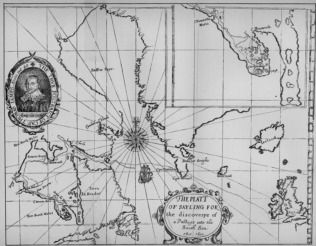
English: James, Thomas. The Platt of Sayling For The Discoverye Of A Passage Into The South Sea 1631-1632 [facsimile]. [1:21,542,400]. In: Christy Miller. The Voyages of Captain Luke Foxe of Hull, and Captain Thomas James of Bristol, in Search of a Northwest Passage, in 1631-32 with Narratives of the Earlier Northwest Voyages of Frobisher, Davis, Weymouth, Hall, Knight, Hudson, Button, Gibbons, Bylot, Baffin, Hawkridge, and others. London: Hakluyt Society, 1884. As reproduced by, Hakluyt Society, vol II, First Series, No. 89.
The title of this map states clearly the intention of the voyage to North America undertaken by Captain James. He entered Hudson Bay to search for and hopefully discover a passage leading west into the Western (or Southern) Ocean. His purpose was not fulfilled. Interestingly, James indicated on his map the wider arena of exploration in the quest for the Northwest Passage, by including the northern regions of Foxe Basin, Davis Strait and Baffin Bay. During his attempt he clarified the character of the west mainland shore south of Cape Henrietta Maria, and made unnecessary further search south of the Nelson river for this western waterway. James erroneously made Southampton Island into a peninsula, although he had not traveled into its immediate area. (Warkentin and Ruggles. Historical Atlas of Manitoba. map 6, p. 26) Map originally printed in black in Thomas James, The Strange and Dangerous Voyage of Captaine Thomas James, in his intended Discovery of the Northwest Passage into the South Sea Wherein the Miseries Indured Both Going Wintering Returning & the Rarities Observed both Philosophicall and Mathematical are related in this Journal of it. London: 1633. |
||
| Date | |||
| Source | The Platt of Sayling For The Discoverye Of A Passage Into The South Sea 1631-1632 (1894) | ||
| Author | Manitoba Historical Maps | ||
| Other versions |
|
_-_2_foldout_map_The_Platt_of_Sayling_-_1_full_view.png)
.jpg&redirect=no)
| Camera location | | View this and other nearby images on: OpenStreetMap |
|---|
Licensing
edit
- You are free:
- to share – to copy, distribute and transmit the work
- to remix – to adapt the work
- Under the following conditions:
- attribution – You must give appropriate credit, provide a link to the license, and indicate if changes were made. You may do so in any reasonable manner, but not in any way that suggests the licensor endorses you or your use.
| This image was originally posted to Flickr by Manitoba Historical Maps at https://www.flickr.com/photos/11496488@N07/1129105411. It was reviewed on 15 November 2009 by FlickreviewR and was confirmed to be licensed under the terms of the cc-by-2.0. |
File history
Click on a date/time to view the file as it appeared at that time.
| Date/Time | Thumbnail | Dimensions | User | Comment | |
|---|---|---|---|---|---|
| current | 18:07, 15 November 2009 | | 3,095 × 2,412 (3.74 MB) | Geo Swan (talk | contribs) | {{Information |Description=James, Thomas. The Platt of Sayling For The Discoverye Of A Passage Into The South Sea 1631-1632 [facsimile]. [1:21,542,400]. In: Christy Miller. The Voyages of Captain Luke Foxe of Hull, and Captain Thomas James of Bristol, in |
You cannot overwrite this file.
File usage on Commons
The following 2 pages use this file:
File usage on other wikis
The following other wikis use this file:
- Usage on en.wikipedia.org