File:The Tees Goblin railtour to Seal Sands- The way we came - the branch from Port Clarence showing the first level crossing.jpg

Size of this preview: 800 × 498 pixels. Other resolutions: 320 × 199 pixels | 640 × 398 pixels | 1,024 × 637 pixels | 1,280 × 796 pixels | 3,132 × 1,948 pixels.
Original file (3,132 × 1,948 pixels, file size: 1,003 KB, MIME type: image/jpeg)
Captions
Captions
Add a one-line explanation of what this file represents
Summary
edit
| Description |
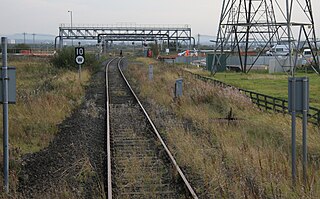
English: The way we came - the branch from Port Clarence showing the first level crossing. NR and BTP vehicles had to block each crossing as the automatic mechanisms would not activate on such rusty track! |
| Date | |
| Source | https://www.flickr.com/photos/58415659@N00/6211682070/ |
| Author | kitmasterbloke |
| Camera location | | View this and other nearby images on: OpenStreetMap |
|---|
Licensing
edit
This file is licensed under the Creative Commons Attribution 2.0 Generic license.
- You are free:
- to share – to copy, distribute and transmit the work
- to remix – to adapt the work
- Under the following conditions:
- attribution – You must give appropriate credit, provide a link to the license, and indicate if changes were made. You may do so in any reasonable manner, but not in any way that suggests the licensor endorses you or your use.
| This image was originally posted to Flickr by kitmasterbloke at https://flickr.com/photos/58415659@N00/6211682070. It was reviewed on 11 June 2021 by FlickreviewR 2 and was confirmed to be licensed under the terms of the cc-by-2.0. |
File history
Click on a date/time to view the file as it appeared at that time.
| Date/Time | Thumbnail | Dimensions | User | Comment | |
|---|---|---|---|---|---|
| current | 17:22, 11 June 2021 | | 3,132 × 1,948 (1,003 KB) | Oxyman (talk | contribs) | Uploaded a work by kitmasterbloke from https://www.flickr.com/photos/58415659@N00/6211682070/ with UploadWizard |
You cannot overwrite this file.
File usage on Commons
The following page uses this file: