File:This map has all 30 if the homesteading states colored in red. The states that did not have homesteading in them are colored in (da7773c1-99e0-41b9-8720-4de79849a4af).pdf

Size of this JPG preview of this PDF file: 463 × 599 pixels. Other resolutions: 185 × 240 pixels | 371 × 480 pixels | 593 × 768 pixels | 1,275 × 1,650 pixels.
Original file (1,275 × 1,650 pixels, file size: 107 KB, MIME type: application/pdf)
Captions
Captions
Add a one-line explanation of what this file represents

|
This media file is uncategorized.
Please help improve this media file by adding it to one or more categories, so it may be associated with related media files (how?), and so that it can be more easily found.
Please notify the uploader with {{subst:Please link images|File:This map has all 30 if the homesteading states colored in red. The states that did not have homesteading in them are colored in (da7773c1-99e0-41b9-8720-4de79849a4af).pdf}} ~~~~ |
Summary
edit| English: W,pdf,HmstdAct Map,rvs1.pdf | ||||
|---|---|---|---|---|
| Photographer |
English: NPS Photo |
|||
| Title |
English: W,pdf,HmstdAct Map,rvs1.pdf |
|||
| Description |
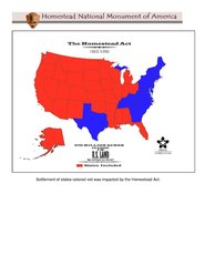
English: This map of the United States has all 30 if the homesteading states colored in red. The states that did not have homesteading in them are colored in blue. This map has all 30 if the homesteading states colored in red. The states that did not have homesteading in them are colored in blue. |
|||
| Depicted place |
English: Homestead National Historical Park, Gage County, Nebraska |
|||
| Accession number | ||||
| Source |
English: NPGallery |
|||
| Permission (Reusing this file) |
|
|||
| NPS Unit Code | HOME | |||
File history
Click on a date/time to view the file as it appeared at that time.
| Date/Time | Thumbnail | Dimensions | User | Comment | |
|---|---|---|---|---|---|
| current | 14:34, 16 January 2022 |  | 1,275 × 1,650 (107 KB) | BMacZeroBot (talk | contribs) | Batch upload (Commons:Batch uploading/NPGallery) |
You cannot overwrite this file.
File usage on Commons
The following page uses this file: