File:Tilia americana range map.svg

Size of this PNG preview of this SVG file: 600 × 600 pixels. Other resolutions: 240 × 240 pixels | 480 × 480 pixels | 768 × 768 pixels | 1,024 × 1,024 pixels | 2,048 × 2,048 pixels | 2,000 × 2,000 pixels.
Original file (SVG file, nominally 2,000 × 2,000 pixels, file size: 421 KB)
Captions
Captions
Add a one-line explanation of what this file represents
Summary edit
| Description |
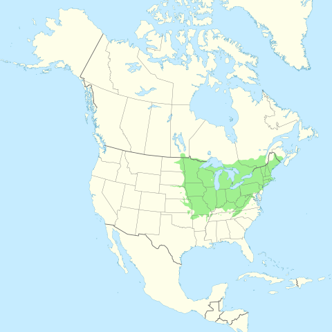
English: Range distribution map of Tilia americana — American basswood. |
| Date | |
| Source |
Own work using Grass GIS and Inkscape. Data sources:
|
| Author | Halava |
Map Projection: Lambert Conformal Conic
Licensing edit
I, the copyright holder of this work, hereby publish it under the following license:
This file is licensed under the Creative Commons Attribution-Share Alike 3.0 Unported license.
- You are free:
- to share – to copy, distribute and transmit the work
- to remix – to adapt the work
- Under the following conditions:
- attribution – You must give appropriate credit, provide a link to the license, and indicate if changes were made. You may do so in any reasonable manner, but not in any way that suggests the licensor endorses you or your use.
- share alike – If you remix, transform, or build upon the material, you must distribute your contributions under the same or compatible license as the original.
File history
Click on a date/time to view the file as it appeared at that time.
| Date/Time | Thumbnail | Dimensions | User | Comment | |
|---|---|---|---|---|---|
| current | 15:07, 15 August 2011 | | 2,000 × 2,000 (421 KB) | Halava (talk | contribs) | {{Information |Description ={{en|1=Range map of American basswood (''Tilia americana'').}} |Source ={{own}} using Grass GIS and Inkscape. Data sources: * Coastlines, lakes, and borders are from [http://www.ngdc.noaa.gov/mgg/coast/ National Geo |
You cannot overwrite this file.
File usage on Commons
The following page uses this file:
File usage on other wikis
The following other wikis use this file:
- Usage on ast.wikipedia.org
- Usage on be.wikipedia.org
- Usage on es.wikipedia.org
- Usage on fi.wikipedia.org
- Usage on hu.wikipedia.org
- Usage on no.wikipedia.org
- Usage on ru.wikipedia.org